The Duck Chase
After a two-year pause, the dedicated men and women who survey North America’s most important waterfowl breeding grounds were back in the field this spring
After a two-year pause, the dedicated men and women who survey North America’s most important waterfowl breeding grounds were back in the field this spring

Through the cockpit of a single-engine Cessna 206, a prairie pothole glints in the distance, and its coming up fast. Terry Liddick, a pilot-biologist with the US Fish and Wildlife Service (USFWS), locks his eyes on the wetland and takes a deep breath. At 90 miles per hour, holding the plane 150 feet above the ground, hell have just a handful of seconds over the water.
Above the rolling prairie 88 miles north-northeast of Sioux Falls, South Dakota, the plane is a hundred yards from the edge of the pothole when Liddick keys a small microphone attached to the planes steering yoke. The microphone is wired to his helmet. For now, all Liddick has to do is count. And talk fast.
Bluewings, two pair.
Scaup, two pair.
Ringnecks, three pair.
Bluewings, another three pair.
Mallards, a pair.
Canadas, a pair.
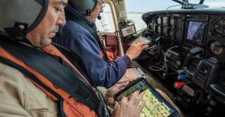
Photo Greg Latza
His voice is recorded in a small receiver mounted on the side of the cockpit by his right knee. Liddick is over the water for only eight seconds, and in that time his mind is racing.
He counts ducks as he approaches the wetland, and counts ducks as he flies over the wetland, and then looks behind him so he can count ducks as hes flying away. You want to see from every perspective and every angle of the sun, Liddick explains. I say to myself: Drill down, drill down, drill down, and find em. Is there something there? What is it? You make every effort possible to identify what you see on those wetlands.
Beside Liddick in the Cessna sits Dave Fronczak, another USFWS wildlife biologist. They wear full flight suits and helmets, which make the tight quarters inside the small plane even tighter. Their shoulders are six inches apart, and Fronczak is similarly focusedlook, drill down, and count, count, count.
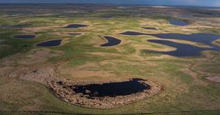
Photo Greg Latza
Liddick and Fronczak play key roles in the annual Waterfowl Breeding Population and Habitat Survey, or BPOP for short. Teams of pilot-biologists and accompanying spotters cover some 80,000 air miles across the northern United States and Canada during the survey. The wealth of data that these dedicated men and women obtain is used to set hunting season lengths and bag limits and ensure healthy waterfowl populations across North America. Traditionally held each May and June, this past seasons fieldwork was particularly momentous. The survey had been canceled for two years straight, in 2020 and 2021, due to pandemic restrictions that grounded aircrews and made cross-border travel impossible.
Collecting the data is lonely, exhausting, exhilarating work, and it involves no small amount of risk for those who take to the air. But this monumental effort is the worlds largest and longest-running wildlife survey, says Mark Koneff, chief of the USFWS Branch of Migratory Bird Surveys and a pilot-biologist who flies the Maine and Atlantic Canada survey area. It also supports a rigorous and science-informed system of management and conservation that directly benefits people across our continent.
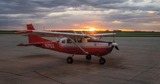
Photo Greg Latza
Conducted jointly by the USFWS and Canadian Wildlife Service (CWS), the BPOP provides annual estimates of the abundance of North Americas breeding waterfowl and May ponds on the landscapes where most of the continents ducks and geese are produced. Announced typically in August, the results are eagerly awaited by waterfowlers, scientists, and other bird enthusiasts. When the numbers are made public, duck hunters cellphones ping and chime. Messages race around the country, parsing what the numbers might mean for duck seasons and bag limits. The data function a bit like the Dow Jones Industrial Averagehealthy BPOP numbers dont guarantee duck-filled skies on any given day in front of any given duck blind. But knowing the status of duck populations helps everyone plan how and where to budget their time and resources. Not to mention vacation days.
In a sense, the BPOP is the worlds most ambitious scavenger hunt. This past May and June, the USFWS sent nine aircrews and two ground crews into the 2-million-square-mile survey area, which stretches east from Alaskas Seward Peninsula to the windswept Maritime shores of Newfoundland and south nearly to the NebraskaSouth Dakota border. The CWS operated three ground crews and also provided three helicopter aircrews who surveyed portions of eastern Canada. Day after day, week after week, crews fly, drive, and hike along standardized transectslinear survey routes that have remained largely unchanged for more than half a century. The goal is straightforward, if incredibly ambitious: The aircrews attempt to count every single duck, coot, swan, and Canada goose within a 400-meter-wide observation zone200 meters on each side of the planeand every single body of water larger than a queen-sized mattress and at least six inches deep. If its big enough to support a duck brood, it goes into the databaseevery natural wetland and every stock pond, gravel pit, and roadside borrow ditch.
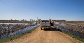
Photo Greg Latza
On a subset of those transects, ground crews follow within 48 hours or less to produce an air-ground sample used to validate and sharpen the aerial survey data. From the road, these personnel pick apart each body of open water. They traipse through flooded bulrushes to flush hidden ducks. They wait out birds that slip from view behind cattails and willows, and they wade sloughs and streams to flush birds that are hunkered out of sight.
The ground crew has one crucial goal, explains Stephanie Catino, a biologist with the USFWS Branch of Monitoring and Data Management and the chief of the eastern Dakotas ground crew. Count every duck on the segment. To do that requires getting landowner permission to cross private lands and navigating belligerent cattle, barbed wire fences, and washed-out farm roads. Not to mention hordes of ticks, mosquitoes, and the occasional riled-up cattle dog.
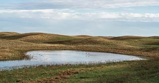
Photo Greg Latza
And every afternoon, after every survey, the biologists trudge back to middle-of-nowhere hotel rooms to turn their notes and voice recordings into detailed spreadsheets sent to the USFWS Division of Migratory Bird Management in Laurel, Maryland. There, teams of statisticians and quantitative biologists pore over the mountains of data to ultimately estimate breeding waterfowl numbers and habitat conditions in each survey area. These estimates are used along with other data from banding and harvest surveys in models that help us assess how the environment and human actions like hunting affect waterfowl populations, Koneff says. These models and our monitoring programs are key components that feed into the harvest strategies that have been developed collaboratively between the USFWS and Flyway Councils to determine appropriate harvest regulations.
The aerial breeding counts that evolved into the BPOP program began in 1947. Those efforts led to standardized surveys in two major survey regionsthe traditional survey area from Alaska across central Canada to the northern plains of the United States, which has been operational since 1955, and the newer eastern survey area covering eastern Canada and Maine, which was established in 1990.
From the beginning, the tales of pilot-biologists seemed like something out of the movies. Early aircrews slept in canvas tents pitched beside their planes on the far northern tundra. Incredible stories trickled out of the north of pilots forced to the ground by wicked storms and bashing through barbed-wire fences, sparks blazing. And of witnessing firsthand the splendor of untrammeled country. Skiing down a steep mountainside is the sport of kings, wrote a pilot in the 1930s who flew for the US Biological Survey, the forerunner of the USFWS, but flying over that magnificent [landscape] beyond the edge of the bush country is a fit diversion for the gods.
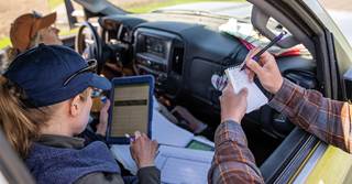
Photo Greg Latza
An element of danger accompanies each flight, to be sure. In just the second year of the original surveys, pilot Leon D. Cool was flying the shoreline of Utikuma Lake in Alberta when a flock of ducks flared in front of his US Army surplus Stinson L-5 aircraft. One duck struck the left strut and another lodged in the engine cowl. Cool completed an emergency landing, but the Stinson mired in wet marsh. The crew bivouacked on the mosquito-ridden lakeshore, and the next morning were awakened by a man who rode up on a small pony. He assessed the situation, left to get his family, and returned with two wagons and two teams of horses, which skidded the plane to firm ground.
A young Terry Liddick was hardly immune to the intoxicating draw of such stories, and flying for the USFWS has been the fulfillment of a childhood dream. As a young teenager, he read an article in Ducks Unlimited about the surveys and was fascinated. I was just a young dumb kid in Pennsylvania who hardly knew a black duck from a mallard, he laughs. But when I learned that there were these people who flew planes to count ducks, I knew right then thats what I wanted to do when I grew up.
That passion is shared by the ground crews. Its hard work, Catino says. We start early, and we get back late. We drink a lot of coffee and eat a lot of candy. But its a real honor to be one of the biologists adding to this kind of knowledge base.
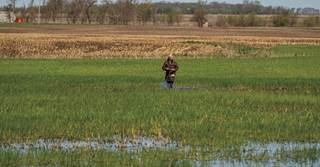
Photo Greg Latza
I can speak for a lot of us, Liddick says. The excitement is huge every year. That has never changed. As far as wildlife surveys go, this is the crme de la crme.
Coursing over the Dakota prairies, what is striking is how little the basic data-collecting aspect of the surveys has changed. Notebook computers and GPS units have largely replaced pens and notepads and paper maps. The data is fed into increasingly complex algorithms and digested by ever-more-powerful computers. And USFWS and university partners are even studying remote sensing and machine learning technologies. But nothing comes close to the ability of a well-trained, focused, and passionate human observer. Methods have remained surprisingly consistent over the decades, Koneff notes. Visual counts by human observers are still the most reliable and efficient means of collecting data over such a vast area for relatively small-bodied wildlife like waterfowl.
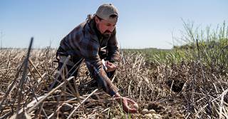
Photo Greg Latza
In the air, survey crews have to recognize the color, size, profile, and behavior of different speciesalmost instantly. Over his 15 years of flying waterfowl surveys, Liddick has learned to identify ducks at a distance using field marks such as the white wing patches of gadwalls and wigeon, the facial crescents of drake blue-winged teal, and the outer white tail feathers of mallards. And bird by bird, transect by transect, the numbers build to create a snapshot of how an entire continents population of waterfowl is weathering the challenges of raising broods in a changing environment.
When Liddick climbs into the plane, banks into a transect, and starts to count ducks, it puts him in the zone, he says. Along some transects he might fly over 100 different wetlands. Its game on. You know what youre up against. The focus is incredibly intense. You are looking and digging and trying to see into every nook and cranny. And of course, I have to glance up every 20 seconds or so to make sure nothings coming thats going to kill us. Remaining focused isnt as hard as you think it might be.
But you know what you have to do, and were all out there because we really want to be doing this, to find every duck we can.
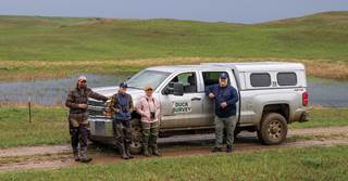
Photo Greg Latza
Share this photo
Ducks Unlimited uses cookies to enhance your browsing experience, optimize site functionality, analyze traffic, and deliver personalized advertising through third parties. By continuing to use this site, you agree to our use of cookies. View Privacy Policy