Waterfowl Breeding Population and Habitat Survey
From setting harvest regulations to studying changes in population size, the annual May waterfowl survey has provided for over 65+ years the most important dataset for North American waterfowl managers. Learn more about how it happens
The Waterfowl Breeding Population and Habitat Survey (BPOP) or "May Survey" is conducted annually in the United States and Canada to estimate breeding population sizes for most waterfowl species in North America. The world's most thorough and accurate wildlife survey effort is described in detail below.
Overview
The BPOP Survey is a collaborative effort between the US Fish and Wildlife Service (USFWS), Canadian Wildlife Service (CWS), state and provincial agencies, and other conservation organizations. The primary goal of the survey is to provide data that helps managers track the status and health of waterfowl populations and their habitats, while providing information that is used to set annual hunting regulations. The survey typically takes place May through June when waterfowl are breeding and nesting. The survey is conducted along more than 55,000 linear miles of transects encompassing over 2 million square miles across the northern United States and Canada.
Each year, pilot-biologists and observers fly fixed-wing airplanes at low altitude (150 feet) on established transects throughout the continent's major waterfowl breeding landscapes, including the Prairie Pothole Region, Eastern Boreal Forest, Western Boreal Forest, and coastal and riverine floodplains of Alaska, among others. During the surveys, both pilot and observer count all the waterfowl visible within 1/8 of a mile on either side of the transect. Waterfowl are recorded by species, which requires extensive training and experience for rapid and confident identification. In the Prairie Pothole Region, survey protocol requires the observer and pilot to also the number of "ponds" that contain water, as this provides an index of habitat conditions in that important region (more on pond counts below).
Ground crews conduct companion surveys along a subset of the aerial transects to calculate "visibility correction factors" that will later be used to adjust aerial counts to account for birds undetected by airplane crews. Adjusted counts are then extrapolated across the survey areas to generate total breeding duck population sizes for key nesting areas.
In eastern portions of the survey areas, breeding duck populations are estimated using a combination of counts from fixed-wing airplanes and helicopters. These methods are used to improve survey results in remote areas of the Eastern Boreal Forest where ducks are more difficult to observe. These improvements have proven most important for high-priority species such as the American black duck.
Survey Areas
The May Survey is defined by two survey areas—the "Traditional Survey Area" and "Eastern Survey Area." The Traditional Survey Area covers 1.3 million square miles in western Canada, Alaska, North Dakota, South Dakota, and Montana. The survey for these regions has been conducted since 1955. The "Eastern Survey Area" covers 0.7 million square miles of eastern Canada and Maine, but data from this region has been collected since 1990. Due to changes in survey methodology, the Eastern Survey Areas, as currently defined, has been surveyed only since 1996.
Waterfowl Breeding Population and Habitat Survey Coverage Map:
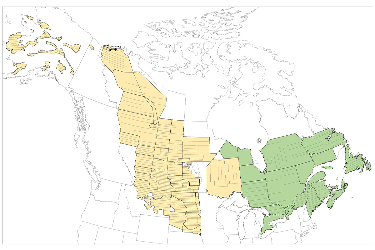
Strata and transects of the Waterfowl Breeding Population and Habitat Survey (yellow = traditional survey area, green = eastern survey area). Photo Credit: Meghan Eyler/Migratory Bird Program, USFWS
Waterfowl Species Most Encountered on the Waterfowl Breeding Population and Habitat Survey
- Mallard - Anas platyrhynchos
- Gadwall - Mareca strepera
- American wigeon - Mareca americana
- Green-winged teal - Anas crecca
- Blue-winged teal - Spatula discors
- Northern shoveler - Spatula clypeata
- Northern pintail - Anas acuta
- Redhead - Aythya americana
- Canvasback - Aythya valisineria
- Scaup (Greater - Aythya marila and Lesser - Aythya affinis)
- American black duck - Anas rubripes
- Ring-necked duck - Aythya collaris
- Goldeneye (Common - Bucephala clangula and Barrow's - Buchephala islandica)
- Merganser (Common - Mergus merganser, Red-breasted - Mergus serrator, and Hooded - Lophodytes cucullatus)
Habitat Conditions and May Pond Counts
"May ponds" are the index of wetlands obtained at the same time the waterfowl are counted, hence the Habitat portion of the survey. Generally, waterfowl populations respond positively when wet weather returns to the breeding grounds. Thus, May pond counts and breeding duck numbers serve as an early indicator of the upcoming fall flight.
Waterfowl Population Status Report
The survey and its results are a foundational component of science-based conservation and harvest management for waterfowl populations in North America, and they are essential for our broader efforts to sustain healthy waterfowl populations and their habitats. Thus, the results from this survey are highly anticipated each year by managers and hunters alike.
After the survey concludes and the reams of data have been analyzed, the USFWS publishes its annual Waterfowl Population Status report that summarizes data on the distribution, abundance, and population trends of surveyed waterfowl species. The full report is published annually and is made available to the public. To learn more and access information about waterfowl population status reports, visit https://www.fws.gov/project/waterfowl-breeding-population-and-habitat-survey.
Survey and Report's Impact
- Informs annual hunting regulations
- Monitoring and assessment of waterfowl population trends and habitats
- Enables research on factors driving waterfowl population change
- Helps identify long-term patterns of landscape change and potential conservation concerns
The spring surveys provide the scientific basis for many management programs across the continent, including hunting season dates and bag limits. Individual states set their hunting seasons within a federal framework of season length, bag limits, and dates. Hunters should check the rules in their states for final dates and bag limits.