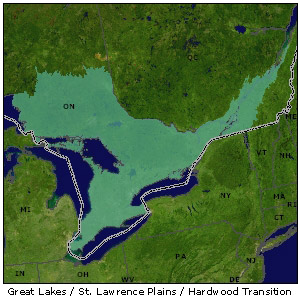
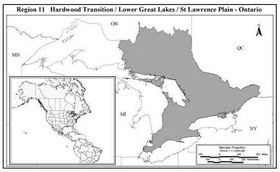
Hardwood Transition / Lower Great Lakes / St. Lawrence Plain - Ontario
Level II Ducks Unlimited conservation priority area, its wetlands support the largest freshwater system in the world
The wetlands of Ontario's Great Lakes and the St. Lawrence lowlands of Québec support the largest freshwater system in the world. The region has lost more than half of its original wetlands to agriculture and other developments. The approximately 2.5 million acres of remaining wetland habitat supports areas of relatively high breeding waterfowl densities, and the region as a whole, provides a significant contribution to waterfowl production within the Great Lakes basin and continentally.
Importance to waterfowl
- The lower Great Lakes and associated coastal wetlands provide critical habitat for waterfowl migrating in both spring and fall.
- Spring and fall migrations consist of large numbers of diving ducks.
- Southern Ontario is home to a great diversity of bird life, with the richness of the species rivaling anywhere else in Canada or the United States during the breeding season.
Habitat issues
- The recent recovery of beaver populations has resulted in extensive complexes of highly diverse wetland habitats that are used by breeding waterfowl.
- Conflicts with recreational development pose additional threats to the long-term health of beaver populations and thus the significant wetland resources within the Hardwood Transition region.
- Human impacts on wetlands and wildlife habitat in this region are the highest on the continent.
DU's conservation focus
- DU is working to protect remaining habitats from continuing threats of urbanization, shoreline development and intensive agriculture.
- Programs include wetland securement/restoration, Ontario Land CARE (OLC) and grassland restoration initiatives in agricultural landscapes and beaver pond management in forested landscapes.
- Work with agriculture to ensure that current and future agricultural activities incorporate wildlife habitat conservation.
- Support public policies that affect wetlands and associated habitats.
Canadian provinces in the Hardwood Transition / Lower Great Lakes / St. Lawrence Plain - Ontario region
Ontario
Background information on DU's Hardwood Transition / Lower Great Lakes / St. Lawrence Plain - Ontario conservation priority area
The Great Lakes-St. Lawrence (GLSL) biome of Canada includes southern parts of Ontario and Quebec plus a small part of northwestern New Brunswick. Within Ontario, the GLSL encompasses all of the Lower Great Lakes/St. Lawrence Plain and the southern half of the Boreal Hardwood Transition NABCI Regions. Within the GLSL of Ontario, three unique landscapes (Mixed Woodland Plain, Shield and Coastal) have been identified. Although there is considerable diversity within each of these areas, there is sufficient homogeneity within to allow effective development of habitat conservation programs for each. Each of these areas is important to waterfowl in its own right, however, each plays a different role in the biology of Ontario waterfowl.
Current habitat programs
A comprehensive set of programs and initiatives developed specifically to address habitat limitations and encourage growth in duck populations are currently being delivered in priority areas within the various landscapes of the GLSL. These include wetland securement/restoration, Ontario Land CARE (OLC) and grassland restoration initiatives in agricultural landscapes and Beaver Pond Management in forested landscapes.
Wetland Securement and Restoration - Securement involves the legal protection of critical breeding and migration habitat through conservation easements, agreements or leases, and purchases. Recent legislation provides the ability to negotiate perpetual conservation easements, and this technique is used where possible as a cost efficient alternative to the purchase of critically important habitats. Provincial Crown land dedication occurs on public lands associated with key breeding areas. Conservation agreements on wetland restoration, enhancement and agricultural initiatives secure valuable waterfowl habitats on private lands within southern Ontario. Wetland restoration is used restore hydrologic function in degraded habitats. This technique requires the co-operation and partnership of many groups (e.g. Federal and Provincial Crown, Conservation Authorities, and a large number of private landowners). Wetland securement and restoration is focused within the Mixed Woodland Plain and Coastal regions of the GLSL.
Ontario Land CARE
Upland initiatives delivered under the OLC program in agricultural landscapes of the Mixed Woodland Plain region to improve the breeding waterfowl value of wetland and associated habitats. The intent of OLC is to conserve wetlands and promote long term, sustainable land use changes in the agricultural landscape. Programs directed at modifying existing agricultural practices have a two-fold purpose. The first is the long-term securement (minimum 25 years) of the existing wetland habitat and where possible, rehabilitation and creation of new wetland areas. The second purpose is to positively affect adjoining upland areas by promoting changes in agricultural practices that not only benefit waterfowl and other wildlife, but are also economically attractive and thus sustainable from an agricultural standpoint. Direct program techniques employed include modified grazing systems, conversion of cultivated lands to forages, cover establishment on fragile or marginal lands, conservation tillage demonstrations and making flushing bars available for use during hay harvesting. This program also involves a co-operative approach with private landowners and many partnerships.
Grassland restoration
Native grasses and forbs provide long-term benefits as upland cover for nesting waterfowl and a wide range of birds and mammals. This technique is used in agricultural landscapes within the Mixed Woodland Plain and Coastal regions to promote permanent retirement of marginal and fragile lands. The native grass program is strategically implemented around critical coastal and inland wetlands providing an important buffer to disturbance, improving runoff water quality and providing important nesting habitat.
Beaver Pond Management
The Beaver Pond Management program is implemented on large blocks of Crown and private land ranging up to 20,243 ha in area and encompassing complexes of 200-500 beaver ponds in various stages of succession. Beaver ponds are considered the most important waterfowl-breeding habitat in Ontario and are greatly influenced by forest management and fire suppression practices. Partnerships and cooperative efforts with Forestry Companies and the Ministry of Natural Resources will focus on modifying current forest management practices, policies and guidelines for the benefit of beaver populations, which in turn benefit wetlands and waterfowl. Small changes in current forestry management activities will have large-scale, significant and sustainable benefits to waterfowl and other wetland dependant wildlife. Direct program techniques under the Beaver Pond Management program will center on addressing waterfowl breeding limitations through nest box placement and upland management.
Mixed Woodland Plain landscape
The Mixed Woodland Plain landscape is located from the southern extent of Ontario northward up to the Precambrian Shield Region of central Ontario. This landscape is tremendously diverse and includes physiographic features such as sand, clay, limestone and till plains, which are interspersed with moraine and drumlin features. Prior to European settlement this region had large areas of seasonally flooded swamps in the southwest and expanses of aak savannah interspersed with tall grass prairie through the southern and central regions. While much of the eastern and central regions were covered by mixed deciduous/coniferous forests. Land use activities with major influences in this region have been agriculture, forestry and urban expansion. There is no doubt that agriculture has had the greatest influence to date, impacting over 3 million ha within the Mixed Woodland Plain. The amount of land in agricultural production varies from 80-90% of the land area in the southwest and east to as little as 5-10% in central and northern portions.
In the past, wetlands in the GLSL have been viewed as wastelands and a hindrance to human progress. Large-scale drainage of the Mixed Woodland Plain landscape began as early as the 1880s with passage of the Ontario Drainage Act that offered farmers financial assistance to drain their lands. Urban development, including transportation and service (hydro, gas/oil) corridors, has also been responsible for high wetland loss and by 1967 over half of the original 2.4 million ha of southern Ontario's wetlands had been lost (Snell 1987). Loss in areas of the southwest and east has reached 90% and is among the highest loss rates observed in Canada.
Throughout the Mixed Woodland Plain, many of the wetlands that remain have been degraded and are of reduced value to waterfowl. However, despite extensive loss of wetlands within the region, quality wetlands and wetland complexes that support relatively high densities of breeding waterfowl still exist (Gabor et al. 1999). These are typically associated with low to moderate agricultural intensity, a result of currently unfavourable "land improvement" conditions. Since the mid 1900s beaver populations have recovered from previous over trapping thus helping to mitigate extensive wetland loss through their wetland creation activities.
The Mixed Woodland Plain is particularly valuable as breeding habitat to mallard, wood duck, blue-winged teal, green-winged teal, black duck, hooded merganser and Canada geese. Of these, mallard, wood duck and Canada geese make up a large percentage although in the recent past blue-winged teal were an important component of the breeding waterfowl population. Since mallards have expanded in the region, black ducks have correspondingly declined. Breeding mallard numbers began to rise in Ontario after 1950 and have grown to be the most common breeding duck in the region. CWS data shows the most abrupt increase in the number of mallards observed during surveys through the 1970s – 1980s. Since that time the number of mallards counted during ground surveys have leveled off in southern Ontario suggesting that mallards have saturated this landscape and are now limited by habitat (CWS Unpublished).
Human threats (i.e. urban expansion, agricultural activities) to much of the remaining waterfowl habitats of this region remain high. Fortunately southern Ontario society is beginning to see wetlands in a new light and acknowledge the value of this diminishing resource. There is tremendous opportunity to revive the expansion of waterfowl populations in the GLSL. Highly productive soils, historic wetland density and the conducive climate of this region affirm that the Mixed Woodland Plains is capable of supporting much greater densities of breeding waterfowl. The rapid increase in breeding populations of mallard, wood duck and Canada geese attest to the productivity of this region for breeding waterfowl.
Goals
- Sustain breeding waterfowl populations to a mean of 10 breeding waterfowl pairs/km2.
- Secure an average of 8-10 wetlands/km2 in a combination of habitats ranging from ephemeral to permanent to support the waterfowl breeding pair goal.
- Secure a minimum of 1 permanent wetland/km2 as suitable habitat for brood rearing.
- Secure 30-40% upland nesting cover of which 5-10% is forested to meet cavity-nesting requirements.
Assumptions
- The waterfowl population goal of 10 breeding waterfowl pairs/km2 is achievable working within the confines of current land use activities (agriculture, forestry and urban expansion).
- The size of breeding waterfowl populations are limited by the amount and quality of habitat which in turn has been affected by wetland and upland loss and degradation.
- Waterfowl capabilities or carrying capacities are not equal across all landscapes within the Mixed Woodland Plain landscape.
- Wetland density, type and distribution limit the density of waterfowl breeding pairs in the GLSL.
- Lack of adequate brood rearing habitat in some areas limit population growth because of low brood and duckling survival due to predation.
- Mallard and wood duck breeding habitat needs represent the general habitat needs for other upland and cavity nesting waterfowl species, respectively.
- The amount of nesting cover limits waterfowl population growth in areas with <30-40% cover because of low hen success due to predation.
- Availability of nesting cavities in close proximity to wetlands limits cavity-nesting waterfowl breeding pairs densities.
Strategies
- Ensure that functional wetlands are conserved in the face of the inevitable developments that will accommodate the increasing population.
- Work with agriculture to ensure that current and future agricultural activities incorporate wildlife habitat conservation.
- Support public policies that affect wetlands and associated habitats.
- Motivate the public (both general and targeted publics) to take actions in support of wetland habitat conservation.
Shield landscape
The Shield landscape is located between the Boreal Forest of northern Ontario and the Mixed Woodland Plain to the south. The area is underlain by Precambrian granite bedrock, with a shallow soil layer. Climate and natural disturbances such as fire, insects and disease have played key roles in the development of forest communities found throughout this 5 million ha area. This landscape once consisted of large, contiguous mature mixed coniferous and deciduous forests interspersed with a patchwork of wetlands, rivers and lakes and areas that had been disturbed by fire, windthrow and disease. Since European settlement, forestry, hydroelectric, industrial and recreational activities have modified this landscape. Land tenure is approximately 50% private and 50% public land, however there tends to be more privately held land in the southern portions of the Shield and higher proportions of public land in the northern half of the Shield. The loss and degradation of wetlands and uplands is relatively low compared to southern Ontario and, although this landscape is by no means pristine, it appears to be a relatively intact ecosystem.
Wetland ecosystems and their maintenance (particularly the beaver pond complexes) are key to the waterfowl resource in this landscape. The most significant feature of the Shield ecosystem is that it is driven by a combination of repeated natural and human induced, cataclysmic, cyclic disturbances caused by fire, insect outbreak, wind damage or forestry activities. Historic large-scale natural disturbances such as fire and disease have provided the conditions necessary for the establishment and regeneration of shade intolerant species such as poplar and birch which are crucial food supplies to sustain beaver populations and in turn create wetland habitats.
Natural fire disturbances within the riparian zones throughout the 1920s, 30s and early 40s combined with recovery of beaver populations from over trapping caused a rapid expansion of beavers and hence wetland habitats that continue today. Unfortunately provincial fire suppression policies changed to aggressively suppress fire disturbance within the landscape partly in response to increasing human population. Concurrently forest policies and management practices have "protected" the riparian areas from virtually all forest harvesting disturbances. In much of the Shield area, a wide buffer must be left along all riparian areas to address soil erosion and fisheries values issues. These two factors combined with silvicultural activities that discourage aspen have created riparian habitat conditions that promote shade tolerant trees and severely limit tree species necessary for beaver colonies to sustain themselves.
This landscape functions primarily as breeding habitat for waterfowl, and contributes significantly to the GLSL waterfowl breeding population. More than half of the breeding population consists of mallard and wood duck with a significant portion of the world's hooded mergansers also being produced in this landscape. Other significant breeding species include black duck, ring-necked duck, common goldeneye, Canada geese, and common and red-breasted mergansers. Breeding waterfowl densities vary greatly across the region primarily due to variations in relative fertility and wetland density found throughout the Shield.
The most threatening impact on the waterfowl resource throughout this landscape are the current fire suppression and forest management policies/guidelines which precludes disturbance in the riparian zone over large areas of the shield. In fact, suppression of forest fires has resulted in an overall decrease of disturbance by fifteen fold (Donnely and Harington 1978). Should these policies continue, beaver populations will decline resulting in a significant reduction in wetland habitats and breeding waterfowl capabilities throughout this landscape. Increased cottage development, hydroelectric, mining impacts and transportation corridors also present significant threat to the aquatic ecosystems.
Goals
- Maintain and average of 3 breeding waterfowl pairs/km2.
- Maintain a disturbance regime which mimics historic natural disturbance frequencies in riparian areas in order to create and maintain a mosaic of wetland and upland habitats necessary to sustain the waterfowl goal.
Assumptions
- A recovery of beaver populations has resulted in colonization of most lowland basins. In recent times, this has resulted in near maximum waterfowl production in this landscape.
- Waterfowl capabilities or carrying capacities are not equal across all of the Shield landscape.
- Disturbances such as fire and disease are much less frequent and effect smaller areas now than occurred historically.
- An average annual disturbance of 2% of the total riparian zone within the Shield landscape will simulate historical disturbance frequency and sustain current beaver populations.
- Appropriate forest management activities within riparian zones can mimic natural disturbances.
- Forest management practices such as those that support pileated woodpecker will create conditions that will benefit cavity-nesting waterfowl.
Strategies
- Mimic natural forest succession, especially in the riparian areas and areas immediately adjacent to beaver pond habitats by working closely with the forest industry, provincial government policy makers and planners and by working with the public that will play an increasing role in forest management planning.
- Identify research and evaluation needs to support this approach.
Coastal landscape
The Coastal landscape exists along the shores of the Great Lakes and St. Lawrence lowlands. These coastal wetlands are associated with the largest freshwater system in the world being comprised of 5 lakes with an associated shoreline of more than 15,000 km, and an area of 246,568 km2. The Great Lakes-St. Lawrence system is highly dynamic with its own set of coastal processes, functions and features. Water levels within Great Lakes basins are regulated through a variety of human interventions. There are seasonal fluctuations, annual variations, and long-term cyclic fluctuations. The Great Lakes are also subject to temporary seiches that commonly occur on Lake Erie and Lake St. Clair causing water levels to be altered by up to 2.6m. The GLSL coastal habitats are diverse in nature being based largely on the shoreline morphology, water depths and their associated vegetation communities.
These coastal areas proved historically attractive to early European settlers and their affects on the system date back to the late 18th century. Human impacts on wetland and wildlife habitat in many areas of the Great Lakes ranks with the highest on the continent. Losses of more than 90% of the wetland habitat base have been recorded in some areas. Outright loss has been extensive and remaining habitats face continuing threat from urbanization and intensive agricultural land uses. Impacts range from the indirect regulation of water regimes and introduction of exotic invasive species throughout the system, to the more direct drainage and degradation for agriculture, industry and urbanization. Shoreline hardening and dyking associated with urbanization and agriculture, in conjunction with water level regulation, has restricted the dynamic movement of the shoreline wetland habitat thereby limiting its abundance and quality. Recreational uses also impact both wetland and wildlife through marina development in wetlands and disturbance.
GLSL coastal wetlands are of greatest importance in terms of their value to waterfowl during spring and fall migrations and of relatively minor importance to waterfowl production in comparison. The spring and fall migrations consist of large numbers of diving ducks, sea ducks, dabbling ducks, Canada geese, tundra swans, and coots. A conservative estimate of 2M dabbling ducks migrate through the GLSL most of which are mallards, blue and green winged teal, wood ducks, black ducks, and American wigeon. The Great Lakes and St. Lawrence River are also important to many species of diving ducks during migration. This results from the region's fertility and a mild climate paired with strong water currents, which promotes an unusually long ice-free period. These conditions commonly favor an extended staging period with some species actually over wintering on the Great Lakes. Continentally significant numbers of canvasback, redhead, scaup and ring necked ducks also utilize the Basin enroute along the Atlantic and Mississippi flyways. Dennis et al. (1987) and Ross (1989) collected the most comprehensive data on fall and spring migration for the CWS. Prince et al. (1992) compiled and reported waterfowl migration values for the Great Lakes basin in terms of waterfowl use days. Based on CWS survey data, key migration habitats include the Lake Erie Long Point marshes, Lake St. Clair marshes, Prince Edward County marshes and wetland habitats along the St. Lawrence and Ottawa Rivers. Other significant coastal and inland staging habitats may exist, but currently little or no waterfowl information has been collected. Likewise, data on the importance of coastal habitats to other wetland dependent wildlife, although acknowledged as being significant, is poorly understood.
Goals
- Meet the nutritional, social and time requirements of diving duck species, at NAWMP population goal levels, on coastal habitats in fall and spring.
- Maintain the existing quantity and quality of coastal wetland habitats traditionally relied on by diving ducks in Ontario's coastal landscape.
- Meet the nutritional, social and time requirements of dabbling duck species, at NAWMP population goal levels, and at anticipated increases in breeding dabbling duck populations within Ontario.
- Maintain the quantity and quality of wetland and associated agricultural habitats now available to migrating dabbling ducks.
- Increase the amount of spring migration habitat to a level that supports increased breeding population objectives in Ontario.
Assumptions
- Diving ducks that use these staging habitats rely on them to maintain favorable body condition for breeding and annual survival.
- Diving duck population size using the GLSL varies in response to conditions on the breeding grounds.
- Most diving ducks species (excluding scaup) using the GLSL coastal habitats are at NAWMP goals and the current quantity and quality of migration habitat in Ontario is sufficient.
- Dabbling ducks must be able to exploit adequate staging habitats to maintain favorable body condition for breeding and annual survival.
- Programs developed to meet the waterfowl goals in the mixed woodland landscape will result in increases in dabbling duck populations and thus staging habitat requirements.
- Fall migration habitat is currently sufficient to meet the nutritional, social and time requirements of dabbling ducks migrating through Ontario when populations of these ducks are at NAWMP goals and when breeding population objectives for Ontario have been met.
- Mitigation due to losses of existing wetland areas may be necessary.
- The availability of spring migration habitat has the potential to be limiting.
Strategies
- Ensure that functional wetlands are conserved in the face of the inevitable developments that will accommodate the increasing population.
- Work with agriculture to ensure that current and future agricultural activities incorporate wildlife habitat conservation.
- Support public policies that affect wetlands and associated habitats.
- Motivate the public (both general and targeted publics) to take actions in support of wetland habitat conservation.
- Participate in international ventures that influence the management of the Great Lakes habitats and water levels.
Summary
Common and unique trends are occurring among the three landscapes within the GLSL of Ontario. Subsequently, some common and unique strategies are required to address these trends. Using landscape goals to strategically focus programs and resources within and among the three landscapes of the GLSL will ensure a maximized return for resources invested. As well, integration of current and future habitat conservation activities within of the GLSL will ensure efficient use of available resources.