Gaining Ground
In the fight to save Louisiana's vanishing coast, DU and its partners are using small-scale river diversions to rebuild crucial habitat
In the fight to save Louisiana's vanishing coast, DU and its partners are using small-scale river diversions to rebuild crucial habitat
By Jennifer Boudart
A land-loss crisis. That's a phrase being used to describe the situation along the Louisiana Gulf Coast. While that may sound like hyperbole, statistics bear it out. One-third of the state's coastal marshalmost 2,000 square miles of landhas washed away in a little less than a century. This devastating loss of land continues, with roughly 50 acres of coastal wetlands disappearing every day. Models predict that by 2050, south Louisiana could lose an area of land the size of Rhode Island.
What are the forces behind this land-loss crisis? In large part, it has been construction of levees and jetties along the lower Mississippi River. While this infrastructure has reduced flooding and aided navigation, it has choked off the flow of sediment and freshwater from the river into adjacent coastal marshes. Without sediments to replenish them, these vital wetlands are sinking below sea level and reverting to open water. And erosion, sea-level rise, and saltwater intrusion via man-made canals are hastening the process.
Slowing wetland loss in Louisiana is a high priority for Ducks Unlimited. In fact, Louisiana's coastal marshes, along with those in neighboring Texas, are among North America's most important waterfowl wintering areas. This stretch of the Gulf Coast supports peak numbers of more than 7 million wintering ducks, including gadwalls, American green-winged teal, northern pintails, blue-winged teal, American wigeon, redheads, lesser scaup, canvasbacks, and resident mottled ducks.
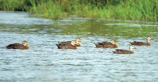
Photo 6 Drakes Photography
"For all this land to just melt away would be a tragedy for waterfowl and people," says Cassidy Lejeune, DU's manager of conservation programs in south Louisiana. "We're losing the coast at an alarming rate, but we're using every tool in our toolbox to help turn the tide."
Lejeune says small-scale river diversionsalso called artificial crevassesare one of DU's most effective and efficient tools for restoring and even rebuilding habitat along the Gulf. Crevassessimple cuts dredged through the banks of channels or passesrestore the flow of sediment and freshwater into areas that have become disconnected from the river. "Nature does the rest," Lejeune says.
Once a crevasse is made, the rebuilding process begins immediately, as sediments start to settle and build up. Within a few months, mud begins to break the water's surface, marking the start of a new "delta splay." Next, the existing seed bank gives rise to plants such as delta duck potato and freshwater three-square bulrush. Within a few years, a diverse suite of habitats is restored.
"Areas of open water that aren't very valuable to fish or ducks are transformed into a mosaic of mudflats, shallow-water areas, beds of submerged aquatic vegetation, and emergent marsh," Lejeune explains. "That variety of habitat is great for fish and wildlife. You may have shorebirds foraging on the mudflats, ducks in the shallow-water areas, wading birds in the submerged plant beds, and rails in the marsh."
In the Mississippi River Delta, DU delivers crevasse projects south of where the levee system ends at Venice. Here, the river divides into natural passes that spread out like toes, giving rise to the area's nickname: the "bird-foot delta." Some of these passes flow through Delta National Wildlife Refuge (NWR) and Pass-a-Loutre Wildlife Management Area (WMA), which are owned and managed by the US Fish and Wildlife Service (USFWS) and Louisiana Department of Wildlife and Fisheries (LDWF), respectively. These agency partners work with DU to identify where crevasses can be created to restore the distribution of freshwater and sediments to open-water areas or in places where channels have filled in. Plans are currently under way to construct seven new crevasses at the mouth of the Mississippi River to restore freshwater and intermediate wetlands on Pass-a-Loutre WMA and Delta NWR. Crucial funding for this work is being provided by the LDWF, USFWS, Coastal Protection and Restoration Authority, North American Wetlands Conservation Act, and James M. Cox Foundation.
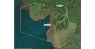
Photo Anna Rollosson, DU
DU is also delivering crevasse projects on Atchafalaya Delta WMA, located at the mouths of the Atchafalaya River and Wax Lake Outlet. Two deltas have formed within the WMA's boundariesthe Main Delta, which is actively managed, and the Wax Lake Delta, which is natural. DU and its partners are working in the Main Delta.
"Unlike the Mississippi River Delta, which is an old delta that is subsiding and degrading, the Main and Wax Lake Deltas are new, accreting deltas," explains Mike Carloss, director of conservation programs in DU's Southern Region. "That makes this a really bright spot on the coast. Crevasses enhance the natural land building that's already happening."
On the Main Delta, marsh acreage is increasing thanks in large part to sediments regularly dredged from the river's navigation channel by the US Army Corps of Engineers. At the direction of the LDWF, the corps uses the dredged material to construct long linear features that mimic the banks of natural delta splays. Over time, these man-made landforms as well as some older natural features become blocked with sediment or closed off. DU works with the LDWF and other partners to cut new crevasses or deepen channels to build new delta splays in open water and continue the land-building process. For example, three new crevasses were recently dredged through the natural banks of passes to reconnect the Atchafalaya River to shallow ponds and lakes that had become largely isolated from the river. Several existing channels were also cleared of sediment to restore water flows. DU's partners in this 1,200-acre wetland restoration project included the LDWF, Energy Transfer, Cargill, and several DU Major Sponsors.
Both the Atchafalaya and Mississippi Deltas are important to waterfowl. "All the species of dabbling ducks and divers that are found in the Mississippi Flyway use these habitats because they're so diverse and typically have really good food resources for waterfowl," Lejeune says. "You get a little bit of everything out there." They are also important to people. Pass-a-Loutre and Atchafalaya Delta WMAs are among the most popular public waterfowl hunting areas in the state. DU's coastal wetland restoration projects not only provide vital habitat for waterfowl and fisheries but also improved boat access for hunters, anglers, and other outdoors enthusiasts.
Mike Carloss grew up in Louisiana. He's seen some of the places in which he worked early in his career vanish into the Gulf. Yet he's seeing some positive signs too. "The work DU and its partners are doing to rebuild the marsh, along with the growing Atchafalaya Delta, gives me hope for the future," he says.
A MASTER PLAN FOR THE MARSH The Coastal Protection and Restoration Authority (CPRA) is a key partner in efforts to save Louisiana's vanishing wetlands. The CPRA is tasked with managing the state's 50-Year Comprehensive Master Plan for a Sustainable Coast. The plan calls for diverting freshwater and sediment from the Mississippi River on a large scale and placing structures on navigation channels to prevent saltwater intrusion from damaging fragile interior wetlands. According to the CPRA, Louisiana's coastal wetlands help protect infrastructure that supplies 90 percent of the nation's outer continental shelf oil and gas, 20 percent of the nation's annual waterborne commerce, and 26 percent (by weight) of the continental US commercial fish harvest. Clearly, the loss of Louisiana's wetlands would have consequences far beyond the state.
Share this photo
Ducks Unlimited uses cookies to enhance your browsing experience, optimize site functionality, analyze traffic, and deliver personalized advertising through third parties. By continuing to use this site, you agree to our use of cookies. View Privacy Policy