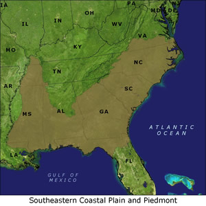
Southeastern Coastal Plain and Piedmont
Level III Ducks Unlimited conservation priority area, providing wintering habitat for at least half of Atlantic Flyway waterfowl
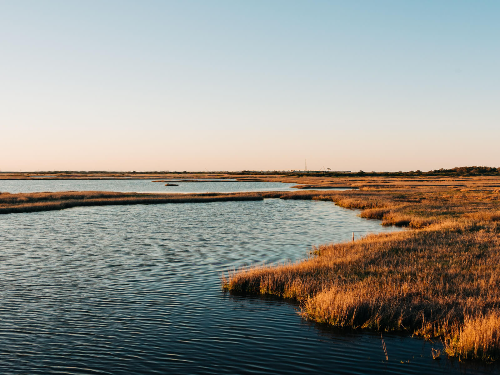
The Southeastern Coastal Plain is located between the Piedmont to the north and the Atlantic Ocean to the east and covers a large portion of the southeastern United States. The South Atlantic coastal region encompasses the bays, sounds, and forested agricultural lowlands of North Carolina, which is the second largest estuarine system on the Atlantic coast. Overall, there has been a net loss of habitat throughout this conservation region with bottomland hardwood wetlands in North Carolina sustaining the greatest losses.
Importance to waterfowl
- Provides winter habitat to at least 50 percent of the waterfowl in the Atlantic Flyway.
- Seasonally flooded bottomland hardwood forests in the region are used by breeding wood ducks and a variety of wintering waterfowl.
- The bays and sounds of North Carolina are important to a number of dabbling and diving ducks, Canada geese and tundra swans.
- Offshore habitats are used by up to 100,000 scaup during most winters.
- North Carolina now winters up to 75 percent of the Atlantic Flyway canvasbacks and large numbers of the Atlantic subpopulation of Canada geese.
Habitat issues
- North Carolina has lost 50 percent of its original wetlands.
- Large, privately owned plantations create an unparalleled opportunity to achieve significant land and water protection.
- Decline in wintering waterfowl may be due in part to a loss of aquatic vegetation, particularly in the Chesapeake Bay system.
DU's conservation focus
- DU's most notable conservation program in this region has been the Low Country Initiative in South Carolina.
- Expand the conservation easement program to protect the existing waterfowl habitat base, focusing attention on important habitats and watersheds in North Carolina.
- Quantify the relationships of waterfowl populations to available foraging habitat.
States in the Southeastern Coastal Plain region
Alabama | Florida | Georgia | Kentucky | Louisiana | Mississippi
North Carolina | South Carolina | Tennessee | Virginia
Background information on DU's Southeastern Coastal Plain and Piedmont conservation priority area
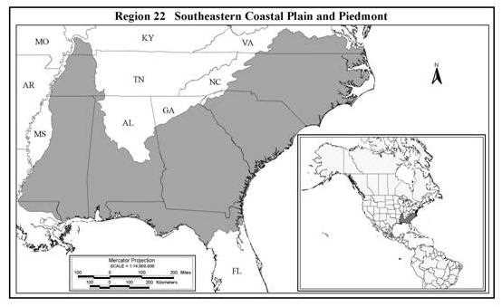
The Southeastern Coastal Plain (Region 22*) extends from the James River in Virginia, southward to approximately Jacksonville, Florida, westward through south central Georgia and Alabama, through roughly the eastern half of Mississippi, and then northward into extreme western Tennessee and Kentucky. It is located between the Piedmont to the north, and the Atlantic Ocean to the east. The western side of this conservation area is bordered by the MAV, while in Florida; it covers the northern portion above the Peninsular Florida Conservation Region. The southern border is the Gulf of Mexico. Geographically, this conservation region covers a large portion of the extreme southeastern U.S., including portions of two separate NAWMP joint ventures – the Atlantic Coast JV (Virginia, North Carolina, South Carolina, Georgia, and Florida only) and the Gulf Coast JV (coastal Alabama and Mississippi only).
The Piedmont Bird Conservation Region, which is located north and west of the SCP, also will be treated in this section of the Conservation Plan. This conservation region includes the Appalachian Piedmont (foothills) and southeastern plains that are dominated by pine (primarily loblolly and long leaf, some short leaf) and mixed pine hardwood forest. Minor alluvial plains are associated with many small rivers in this region and consist of southern bottomland hardwood forest (oak, tupelo, cypress). This region is located between the Appalachian Bird Conservation Region (BCR) and the Southeastern Coastal Plain BCR.
Important wetlands: Lower Southeastern Coastal Plain
The South Atlantic coastal region encompasses the bays, sounds, and forested/agricultural lowlands of North Carolina (originally treated as part of the Mid-Atlantic Coast in the CCP), which is the second largest estuarine system on the Atlantic coast. It also takes in the pocosins, Carolina bays, swamps, estuarine marshes and former rice producing areas of southern North Carolina, South Carolina, Georgia, and extreme northeastern Florida. Minor alluvial floodplains dominated by bottomland hardwood forest occur throughout this portion of the conservation region (Gordon et al., 1989, Hindman and Stotts 1989, Hodges 1998, Sharitz and Gresham 1998).
Within North Carolina, the most important waterfowl habitat occurs in the Currituck-Abemarle-Pamlico Sounds region (Hindman and Stotts 1989). Land use is predominantly forestry, agriculture, and livestock (poultry and swine), which contribute to non-point source pollution that affects water quality and production of submerged aquatic vegetation in the bays and sounds. In this particular area, submerged aquatics are a very important food source for migrating and wintering waterfowl; hence water quality issues are an important management concern. North Carolina has lost approximately 24% of its original bottomland hardwood forested wetlands, with some 185,625 ha lost between the mid-1970s and mid-1980s (Hefner et al. 1994). Overall, North Carolina has lost 50% (2.4 million ha) of its original wetlands.
In coastal North Carolina, conversion of forested wetlands to agriculture and livestock operations is the primary causes of habitat loss (Hefner et al. 1994). While on one hand this conversion has had negative effects on water quality and aquatic vegetation production, it also has made available waste grain as a food source for wintering and migrant waterfowl. However, the net effect on waterfowl carrying capacity in this portion of the region is unknown, but likely has declined. Habitat within the bays and sounds has suffered moderate to severe degradation and subsequent loss of aquatic vegetation has affected waterfowl populations in the region.
Land use and habitat from Cape Lookout, NC, through extreme northeastern Florida, is similar to eastern North Carolina in many respects. Predominant land uses are agriculture and forestry. South Carolina has suffered a net loss of 1% or 24,686 ha of wetlands from the mid-1970s to the mid-1980s (Hefner et al. 1994). Losses primarily are related to development pressure on the coast and immediately inland as people move to find jobs in the tourism-related service industries. Up until about 1900, rice agriculture provided substantial waterfowl habitat. Today, rice is not grown commercially in the region, but in many cases former rice plantations have been purchased, infrastructure renovated, and they are now managed for waterfowl and other wildlife (Gordon et al. 1989).
*Region 22 - NABCI Conservation Regions 27, 29
The coastal rivers, floodplains and marshes of South Carolina are collectively referred to as the Lowcountry and encompass 11,655 km2. The ACE Basin, which takes its name from the confluence of the Ashepoo, Combahee, and Edisto Rivers, consists of the largest undeveloped coastal wetland on the Atlantic Coast. This basin is recognized as the flagship project for the ACJV of the NAWMP. An UNESCO Biosphere Reserve and a Western Hemisphere Shorebird Reserve Network site are located within the project area along with two National Estuarine Research Reserve Systems and six National Wildlife Refuges.
Georgia has suffered loss of approximately 315,566 ha of wetlands from the mid-1970s to the mid-1980s (Hefner et al. 1994). Nearly 202,344 ha of additional wetlands have been converted from forested to scrub-shrub types as a result of timber harvest. Some important forested and coastal wetlands occur in association with Savannah and Altamaha River estuaries and floodplains. Forestry and agriculture are the dominant land uses in this region, and most wetland loss in Georgia has occurred in association with agriculture, forestry, and navigation projects.
Important wetlands: Upper Southeastern Coastal Plain and Piedmont
This portion of the SCP and Piedmont take in higher elevation areas inland of traditional coastal habitats, including portions of the Gulf of Mexico coastal plain in northwestern Florida, Alabama, and eastern Mississippi, and extreme western Tennessee. The Piedmont Bird Conservation region is included in this conservation region.
Beaver ponds comprise important habitat in this region. Arner and Hepp (1989) suggested that the area of beaver ponds throughout the southeastern U.S. was increasing, and in the late 1980s, encompassed at least 288,000 ha of potential waterfowl habitat. Seasonally flooded minor alluvial plains occur along most rivers in this portion of the conservation region. Important seasonally flooded bottomland hardwood forest occurs in conjunction with the Savannah (GA, SC), Chattahoochee (AL, GA), Alabama (AL), Tombigbee (AL, MS), and Pearl (MS) and Big Black (MS) Rivers.
Alteration of hydrology for reservoir construction, flood control and subsequent clearing for agriculture on these and several other river systems has resulted in substantial loss of bottomland forested wetlands (Hodges 1998). However, many reservoirs have become important waterfowl habitat. Over 30 major reservoirs have been constructed for flood control, power generation, municipal water supply and navigation (Johnson and Montalbano 1989). Reservoirs provide over 300,000 ha of open water, an undetermined amount of which provides foraging habitat via production of submerged aquatic vegetation, and all of which provides open water areas for roosting/resting habitat. Eufaula NWR was created as mitigation for reservoir construction on the Chattahoochee River and has become a regionally important wintering area.
The Gulf Coast Region is relatively void of waterfowl habitat and only sparse, scattered concentrations of birds occur from St. Marks NWR, west through the coastal Florida panhandle, until the Mobile Bay and Delta. Within Mobile Bay, highway construction and reservoir construction have altered hydrology such that submerged aquatic vegetation beds are substantially reduced. Over 60,729 ha of bottomland forested wetlands occur in the northern reaches of the Mobile Delta. (Alabama Dept. Conserv. & Nat. Resour, unpubl. data). Farther west, the bays, sounds, and coastal marshes of Mississippi provide winter habitat, particularly for diving ducks (Barry Wilson, Gulf Coast Joint Venture (GCJV), pers. comm).
Overall, there has been a net loss of habitat throughout this conservation region. Generally, bottomland hardwood wetlands in North Carolina have sustained the greatest losses (Hefner et al. 1994). Approximately 50% of the original wetland base is gone in this region, lost to flood control, reservoir construction, development, agriculture, and navigation. From a continental perspective, importance of this conservation region relative to other areas of winter habitat such as the MAV, Gulf Coast and Coastal Prairies, and Southern Great Plains is considerably less. However, the importance, or potential importance, of this region to Atlantic Flyway waterfowl, particularly tundra swans, wood ducks, canvasbacks, ring-necked ducks, and lesser scaup should not be over-looked.
Importance to waterfowl
Lower Southeastern Coastal Plain
Mid-winter survey data for the Atlantic Flyway suggest a long-term decline in the number of most species of wintering waterfowl (Steiner 1984, Hindman and Stotts 1989). The decline is probably a function of multiple, interactive factors, but loss of aquatic vegetation, particularly in the Chesapeake Bay system likely is a significant factor. The bays and sounds of North Carolina are important to a number of dabbling and diving ducks, Canada geese, and tundra swans. Diving duck use of this area increased as habitat quality in the Chesapeake Bay system declined. North Carolina now winters up to 75% of the Atlantic Flyway canvasbacks, large numbers of the Atlantic subpopulation of Canada geese, and nearly the entire population of eastern tundra swans. Geese and swans in particular have adapted to field feeding on waste grain, no longer extensively foraging on aquatic vegetation in shoals and bays. Also, most of the American wigeon that once wintered in the Chesapeake Bay have shifted southward to the North Carolina bays and sounds to take advantage of available aquatic vegetation. The North Carolina bays and estuaries also are significant migration and winter habitat for lesser scaup, brant, and several species of sea ducks.
Numbers of waterfowl wintering in South Carolina and Georgia also have declined in recent years. This decline is perplexing in that, in general, habitat quality and quantity do not appear to have suffered a similar decline. The decline may be related to the overall decline of waterfowl in the Atlantic Flyway where habitat loss, alteration and degradation have been substantial. Alternatively, it has been suggested that many birds have shifted toward more inland habitats associated with major reservoirs where they are not counted during traditional mid-winter inventory flights. Nonetheless, coastal impoundments still winter several hundred thousand waterfowl, particularly green-winged teal, northern shovelers, American wigeon, northern pintails, wood ducks, and mallards, totaling about 30% of the birds typically found in the Atlantic Flyway. Diving ducks, especially ring-necked ducks and lesser scaup, winter in bays and sounds, but in relatively smaller numbers (generally <100,000) compared to North Carolina's (Gordon et al. 1989, Hindman and Stotts 1989).
Overall, this region is most important as winter habitat for tundra swans, Canada geese, and most species of dabbling and diving ducks common to the southern Atlantic Flyway. The SCP wetlands provide winter habitat to at least 50% of the waterfowl in the Atlantic Flyway. It has secondary importance to migrant lesser scaup, most of which winter in Florida. Factors limiting waterfowl use of habitat within the SCP are unclear. Foraging habitat may well be limiting overall, but before conclusions can be drawn the amount of foraging habitat and its value in terms of duck use days (energetic model) must be quantified. Wintering distributions of waterfowl in the Atlantic Flyway in general appear to have shifted, with a net decline in the number of birds using the flyway. Notable decreases have occurred in the Chesapeake Bay and South Carolina. Causes are unclear, but could relate to foraging habitat limitations caused by habitat loss and degradation. Also, waterfowl distributions may have been affected by inland or northward shifts of some species (mallards in particular) related to an increase in available waste grain and open water at more northern latitudes or in association with major inland reservoirs located in the Upper Southeastern Coastal Plain. Disease, severe weather, and other potential limiting factors are not generally significant problems.
Upper Southeastern Coastal Plain
Depending on their state of succession, beaver ponds can provide abundant food to migrating and wintering wood ducks, mallards, ring-necked ducks, hooded mergansers and limited numbers of other species. Beaver ponds provide very important habitat for breeding wood ducks and hooded mergansers (Arner and Hepp 1989). Minor alluvial floodplains throughout this portion of the region occasionally to regularly flood and provide habitat for wood ducks, mallards, gadwall, wigeon, ring-necked ducks, and limited numbers of other species.
Reservoirs provide an undetermined amount of foraging habitat for waterfowl throughout this region. For example, Eufaula NWR, which was created as mitigation for reservoir construction on the Chattahoochee River in Alabama and Georgia, typically over-winters 5,000-10,000 ducks, mostly mallards, green-winged teal, wood ducks, ring-necked ducks and American wigeon. Also on the Chattahoochee River, Lake Seminole in southern Georgia provides winter habitat for an average of 5,000 canvasbacks and approximately 5,000 to 25,000 ring-necked ducks, many of which feed on exotic hydrilla (Georgia DNR unpubl. data). Exotic plants, particularly hydrilla and Eurasian milfoil have become important foods in some southern reservoirs, particularly for gadwall, wigeon, ring-necked ducks, lesser scaup and canvasbacks (Johnson and Montalbano 1987, 1989). There has been a significant decline in exotic vegetation (i.e., hydrilla) on many of these southern reservoirs - Lakes Marion and Moultrie in SC, Lake Seminole (GA/FL), Lake Okeechobee and many others in FL. Aggressive control programs (herbicide and grass carp) are conducted by most of the southern states. In FL and SC, laws mandate control of exotic vegetation. However, there is evidence in FL that hydrilla is becoming resistant to herbicides and they expect to see increases throughout the state.
In northern Florida, the Tallahassee Lakes provide significant winter habitat for ring-necked ducks and lesser scaup (Johnson and Montalbano 1987, 1989). Managed coastal impoundments at St. Marks NWR and Big Bend Wildlife Management Area on the Florida Gulf Coast provide winter habitat for about 10,000 ducks. Offshore, in the general vicinity of the Great Bend/Appalachicola Bay in the eastern Gulf of Mexico, up to 70,000 redheads over-winter, representing perhaps 5-10% of the continental population. This region also winters approximately 40,000 lesser scaup. Few waterfowl over-winter in the Florida Panhandle region. Numbers of waterfowl increase beginning at the Mobile Bay and Delta, where 5,000-10,000 ducks have wintered in recent years. Forested wetlands in the Tensaw-Mobile Delta provide important habitat for wintering and resident wood ducks, and a limited number of other species. Approximately 15,000-20,000 ducks, of which approximately 10,000 are lesser scaup, over-winter in coastal Mississippi bays and marshes.
Importance to other wildlife
The wetlands, estuaries, bays and associated beaches and mudflats provide significant habitat to a diversity of wading and shorebirds. Along the Atlantic Coast, intertidal areas provide significant winter habitat for American oystercatchers, short-billed dowitchers, and dunlins. These areas also are important migration and staging habitat for these species as well as red knots. Substantial numbers of shorebirds also occur in association with mudflats and beaches of the eastern Gulf Coast of Mexico.
Coastal wetlands in this region are important habitat for resident, migrant, and wintering colonial water birds, including several species of herons, egrets, ibis, terns, and brown pelicans. There are at least 3 significant wood stork rookeries with over 700 nesting pairs occurring in the bottomland hardwood swamps of this region. Wetlands throughout this region support numerous colonies of great blue herons, common egrets, snowy egrets, little blue herons, and both black-crowned and yellow-crowned night herons. Populations of these species are not quantified, but they are very abundant and wetlands in this region are very important to both residents and migrants. Nearly the entire U.S. population of endangered wood storks nests either in this region or the adjacent Peninsular Florida conservation region, with at least 3 significant wood stork rookeries with over 700 nesting pairs occurring in the bottomland hardwood swamps of this region (Gough et al. 1998).
One migrant and one resident population of greater sandhill cranes occur in this area. The Eastern Population, which breeds in Ontario, Minnesota, Wisconsin and Michigan over-winters primarily in southeastern Georgia through central Florida. A resident population of cranes occurs in extreme southeastern Mississippi (Tacha et al. 1994). Much of the population of limpkins in North America occurs in association with cypress and bottomland hardwood swamps in the Florida and extreme southwestern Georgia portions of this region, with the remainder occurring in the Peninsular Florida region (Gough et al. 1998).
Barrier islands and some mainland beaches provide significant nesting habitat for loggerhead sea turtles. South Carolina is second only to Florida in numbers of nesting loggerhead sea turtles. These same islands support colonies of several species of terns and brown pelicans. In the Gulf of Mexico, offshore and near shore waters in the Big Bend region of Florida, west to Mississippi Sound, over-winter significant portions of the common loon population in eastern North America. The coastal marshes, bays, and estuaries also are essential nursery habitat for a variety of commercially important marine fish and shellfish, including red drum, flounder, speckled trout, blue crabs, brown shrimp and many others.
Forested wetlands in this region support a variety of neotropical migrant birds. Swainson's, hooded, and prothonotary warblers are common to uncommon in these areas, while swallow-tailed kites and red-shouldered hawks are locally uncommon and common raptors, respectively. At least two species that once were common to uncommon in this region are now extinct or believed so - the Carolina parakeet and Bachman's warbler. Pine uplands within and bordering this region support populations of red-cockaded woodpeckers and Bachman's sparrows.
Conservation programs
Generally, DU conservation programs in this region support and contribute toward the goals of the NAWMP ACJV, and to a lesser extent the GCJV. Presently, both the ACJV and GCJV are revising their habitat goals through an enhanced conservation planning effort. Eventually, revised goals will be developed that will include habitat objectives for waterfowl and other bird groups of importance in the South Atlantic coastal zone as well as the Mobile Bay and Mississippi Gulf Coast portions of this region. Scale of delivery of conservation programs is localized and project-specific within this conservation region, and will remain that way until proactive conservation easement programs or private lands conservation programs are developed and public lands programs are expanded.
DU's most notable conservation program in this region has been the Lowcountry Initiative in South Carolina. Large privately owned plantations ranging in size from 800-21,000 ha (some dating to the 16th century) are the primary landholdings in this portion of the conservation region. This unique situation coupled with interest from many of the landowners creates an unparalleled opportunity to achieve significant land and water protection. Through a multi-agency partnership, 404,858 ha were already under protection by 1998.
The Lowcountry Initiative provides DU a unique opportunity to protect wetland and upland habitats using conservation easements on private lands. Approximately 30,600 ha have been protected by DU via conservation easements through FY2004. DU's conservation easement program accepts easements in perpetuity through its Wetlands America Trust. Such long-term protection conserves large, undeveloped upland and wetland ecosystems for the benefit of water birds, other wildlife, and the threatened and endangered species that occur in the region. Easements likely will remain a significant conservation tool in this region, but DU will begin to focus on proactive habitat restoration and enhancement programs, particularly on private lands in North and South Carolina. In 2004, DU launched its new Sound CARE initiative. The goal of this initiative is to restore 9,000 ha of habitat in North Carolina, while simultaneously raising funds for conservation of breeding habitat through marketing the habitat conservation issues in areas from which the majority of North Carolina's harvest is derived.
Regarding more traditional conservation programs, DU's primary focus to date has been to provide funding via the MARSH program. DU has cooperated with many state and federal agencies in this conservation region to conserve 81,053 ha. Opportunities exist to expand and take a more proactive posture relative to delivery of conservation programs on both private and public land, particularly in coastal North Carolina.
Goals
The primary goal of DU conservation programs in the SCP conservation region is to protect, restore, enhance and manage waterfowl and wetland habitat consistent with the objectives of the ACJV and GCJV of the NAWMP. Specific objectives include:
- Maintenance of 81,053 ha of habitat projects completed through FY2004.
- Protection of an additional 10,000 ha by the end of FY2008.
- Restoration or enhancement of at least 10,000 ha of habitat by the end of FY2008.
- Evaluation of the role of DU in the region with an eye toward expansion of conservation programs. This may include: a) formation of new partnerships and provision of biological and engineering services to assist agencies and private landowners with habitat restoration and enhancement; b) development and delivery of a partnership-driven private lands program; and c) proactive use of conservation easements to protect habitat and stem urbanization and wetland conversion to agriculture and livestock production, particularly in North Carolina.
Assumptions
- Waterfowl are limited by the quantity and quality of foraging habitats in the region through impacts on over-winter survival rates, and potentially on subsequent recruitment.
Strategies
- Evaluate staffing requirements that will enable DU to organize, expand, and serve as a primary partner in the conservation of waterfowl habitat in the SCP.
- Expand the conservation easement program throughout the region to protect the existing waterfowl habitat base, focusing attention on protection of important habitats and watersheds in North Carolina.
- Develop partnerships in cooperation with public agencies and private landowners.
- Work with Field Operations staff, Development staff, and volunteers to secure a level of funding adequate to implement a full range of DU-lead conservation programs in the SCP conservation region.
- Quantify the relationships of waterfowl populations to available foraging habitat.
- Encourage ACJV staff to revise conservation plans for the region along the lines of the foraging habitat models developed for the LMVJV and under development for the GCJV.
- Provide remote sensing and GIS support for the ACJV to further conservation planning in the region.