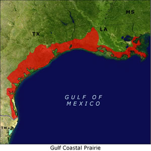
Gulf Coastal Prairie
Level I Ducks Unlimited conservation priority area, wintering millions of ducks and geese each year
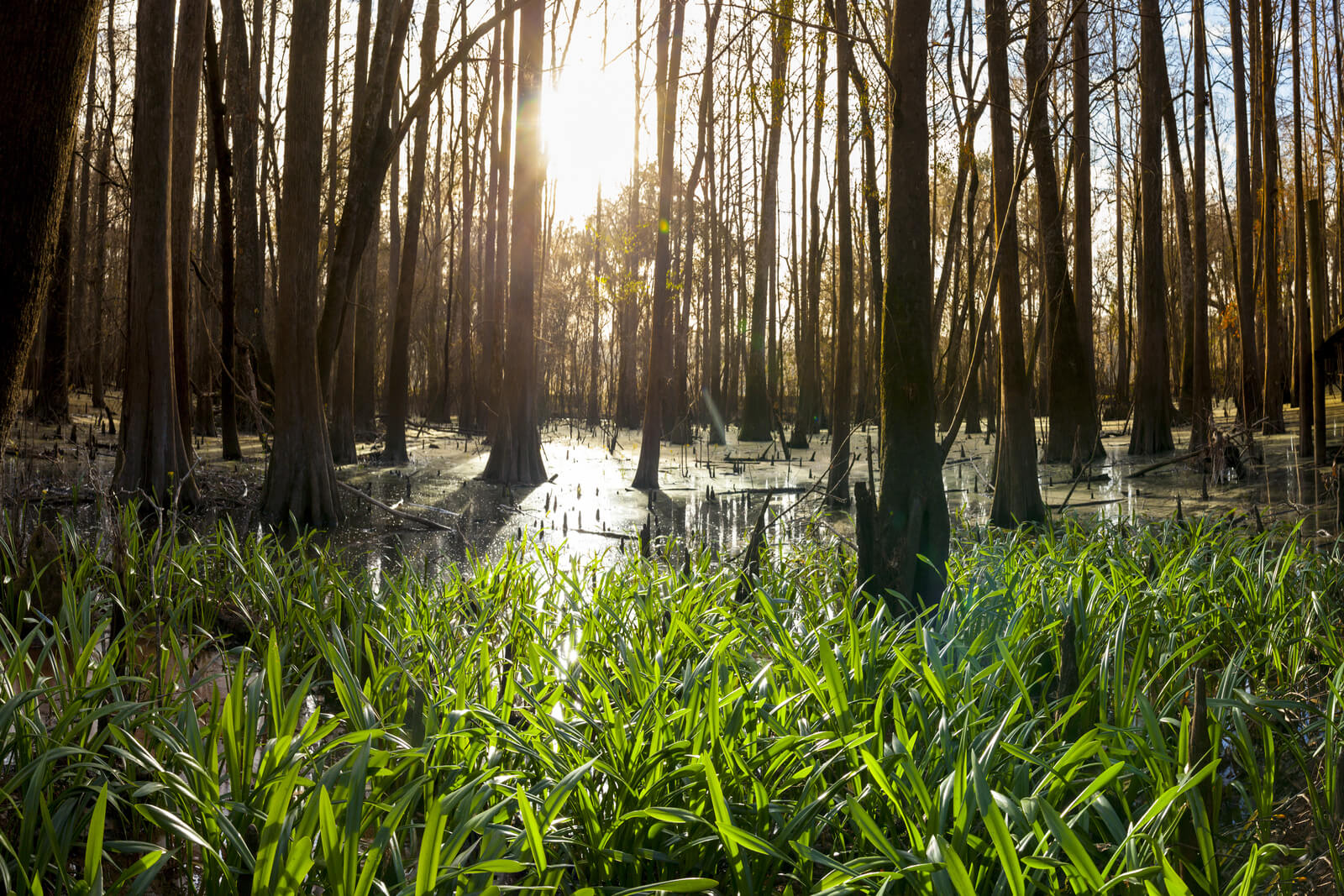
For some waterfowl, the Mississippi Alluvial Valley is not a final destination, but a stopover on the way to a milder winter resort-the Gulf Coast. Stretching from the Mississippi-Louisiana state line, west and south to the mouth of the Rio Grande River, the marshes and bays of the Gulf of Mexico were once among the most productive wetland systems in North America. Today, the region's ability to support waterfowl has been severely compromised by natural and human-induced changes that have caused dramatic loss of wetlands and their associated functions and values. The North American Waterfowl Management Plan Gulf Coast Venture calls for Gulf wetlands to winter up to 13.7 million ducks and 1.5 million geese, making it among DU's highest priorities.
Importance to waterfowl
- Wintering habitat for large continental populations of several species: 95 percent of gadwall, 90 percent of mottled duck, 80 percent of green-winged teal, 80 percent of redheads, 60 percent of lesser scaup and 25 percent of pintails.
- Provides migration habitat for most of the blue-winged teal that winter in Central and South America and wintering habitat for mid-continent lesser snow and white-fronted geese.
Habitat issues
- Gulf coastal marshes have been adversely affected by the construction of levees on the Mississippi River, the Gulf Intracoastal Waterway and numerous navigation canals.
- In the past 50 years, marsh has been lost at a peak rate of about 40 square miles annually.
- More than 1.2 million acres of Louisiana's coastal marsh have been converted to open water since 1932.
- Since 2005, four major hurricanes and the Deepwater Horizon oil spill have accelerated marsh loss and degradation along the Gulf Coast.
- Coastal marsh is further threatened by global climate change and related sea level rise. Net losses of an additional 402,000 acres of coastal wetlands are expected to occur in the next 50 years in Louisiana alone.
- Coastal interior prairie wetlands are being lost to developments and urban expansion.
- Water availability limitations, particularly in Texas are threatening rice agriculture and other managed wetlands along the coast.
- Recent declines in rice acreage in the region contribute to the loss of feeding and resting habitat.
DU's conservation focus
DU is continuing to increase coastal conservation efforts along the Gulf Coast. For a complete breakdown of DU's Gulf Coast Conservation Initiative, visit the Gulf Coast Initiative home.
- Restoration and enhancement of key public land habitats with state and federal partners.
- Restoration and protection of high-quality waterfowl habitat on private lands, including seasonally flooded agricultural land (mainly rice) and natural and managed freshwater and intermediate marshes.
- Advocacy for restoration of natural process necessary to sustain the coastal ecosystem.
- Advocacy for water allocations that support waterfowl habitat, including rice irrigation and wetland management.
States in the Gulf Coastal Prairie region
Louisiana | Texas
Background information on DU's Gulf Coastal Prairie conservation priority area
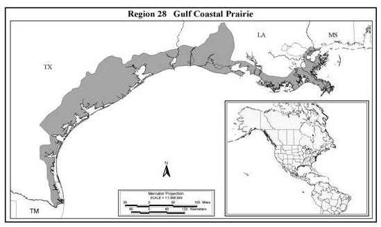
As delineated in the North American Bird Conservation Initiative, the Gulf of Mexico marshes (Region 28*) extend roughly from the Mississippi-Louisiana state boundary west and south to the mouth of the Rio Grande. This region also includes a large area of land that formerly was tall grass prairie interspersed with wetlands that today is largely converted to agricultural production.
The NAWMP GCJV divides the coastal marsh of Louisiana into separate but related initiative areas, the Mississippi River Coastal Marshes (Deltaic Plain) and the Chenier Plain (Gulf Coast Joint Venture 1990). Similarly, in Texas the coast is subdivided into 3 initiative areas, the Upper Texas Coast (Chenier Plain), the Mid-Texas Coast, and the Lower Texas Coast (Laguna Madre). Adjacent to and immediately north of the Chenier Plain and Texas Mid-Coast regions is a band of agricultural land dominated by rice production, sometimes referred to as the wet prairie or rice prairie. This region probably increased in importance to waterfowl when it was converted from wet tall grass prairie to rice agriculture (Hobaugh 1984, Hobaugh et al. 1989, Stuzenbaker 1980, 1984).
The characteristics of the Deltaic Plain historically were driven by the dynamics of the lower Mississippi River. Delta formation processes interacted with the Gulf of Mexico to give rise to a diverse ecosystem ranging from bottomland hardwood swamps and low-energy freshwater marshes to high-energy tidally influenced salt marshes. The Chenier Plain also is tied to Mississippi River Delta activity. When the Mississippi River was active in the western reaches of its delta, sediment was carried westward by near shore Gulf currents and deposited on mudflats that resulted in creation of the Chenier Plain region. Alternatively, when the river shifted east, near shore current carried fewer sediments and eroded shoreline and marsh. The Chenier Plain and wet prairie periodically are interrupted by rivers that drain upland areas to the north. A thorough review of Mississippi River delta formation processes and effects is presented in Louisiana Coastal Wetlands Conservation and Restoration Task Force (LCWCRTF 1998).
*Region 28 - NABCI Bird Conservation Region 37
The Texas Mid-Coast begins near Galveston Bay and ends near Corpus Christi. It is characterized by a relatively narrow band of marsh created in association with the estuaries and bays of minor rivers that drain the region (Moulton et al. 1997). Finally, the Laguna Madre is a shallow embayment stretching along the lower Texas Coast from Corpus Christi to Tamaulipas, Mexico. It is a hypersaline system with few fresh water inputs via rivers, and relatively few openings into the Gulf. Small freshwater wetlands occur immediately inland of the Laguna and provide important dietary fresh water for ducks feeding in nearby hypersaline habitats. Additionally, significant fresh water habitat formerly existed in the now highly agricultural Lower Rio Grande valley (Moulton et al. 1997).
Wetlands along the Gulf coast are declining in size and deteriorating in function resulting from both natural and human induced changes to the system. Historically, the amount of coastal marsh has fluctuated with changes in sea level, delta accretion and subsidence rates, and other factors. In recent history, Louisiana has had approximately 1.36 million ha of coastal marsh. Alarmingly, within the past 50 years, marsh loss rates have exceeded 104 km2/yr with a resultant loss of over 364,219 ha in Louisiana (LCWCRTF 1998). During the 1990s, coastal marsh loss in Louisiana has slowed to an estimated rate of 65-91 km2/year, with projections over the next 50 years that an additional 254,953 ha of marsh, swamps, and islands will be lost, even with completion of planned or proposed large-scale remedial measures (LCWCRTF 1998). Indeed, the LCWCRTF (1998) suggests the entire system of coastal marsh in Louisiana has deteriorated in size and function to the point of being on the verge of collapse, wherein ecological, commercial and cultural values will be lost without rapid and substantial intervention to reverse processes culminating in wetland losses.
Further west in Texas, approximately 1.62 million ha of coastal wetlands existed in the 1950s, but the scope and rate of loss, while substantial, is less severe than in Louisiana. For example, since 1955, approximately 85,264 ha of coastal wetlands have been lost, which is an annual rate of about 23 km2/yr (Moulton et al. 1997). These rates consider changes to coastal marsh as well as to the inland coastal prairies, and techniques utilized to develop these estimates may have underestimated the rate and extent of wetland loss or conversion in Texas (Barry Wilson, pers. comm.).
These data do not reflect wetland loss or change associated with the conversion of the tall grass prairies of southwestern Louisiana to agriculture. Essentially all tall grass prairie that existed north of the coastal marsh has been converted to agriculture. Further, much of the area has been land-leveled, which eliminated many depressional wetlands and upland ridges that were important habitat for mottled ducks and a number of other species (Hobaugh et al. 1989). The value of this habitat to waterfowl prior to conversion is not well known, but this grassland area had a moderate density of shallow depressional wetlands that probably provided fair waterfowl habitat. With conversion to agriculture dominated by rice production, the region increased dramatically in importance to ducks, geese, and shorebirds. Since 1974, rice production in the region has declined 47% as a result of world competition, escalating costs of water for irrigation, and the reduction or removal of government subsidies. Declines in production have been more severe in the Texas Mid-Coast (50%) and Texas Chenier Plain (65%) than in the Louisiana Chenier Plain (40%) (USDA National Agricultural Statistics Service). Land taken out of rice production in some cases is converted to other crops of less (milo) or no (sugar cane) value to waterfowl, dry of wet pasture of moderate value to some species of waterfowl, or is lost to invasive, exotic stands of Chinese tallow tree.
Causes of wetland loss along the Gulf coast are complex, and both natural and man-induced in origin. Two related factors are at the root of much wetland loss in the region: (1) sea level rise; and (2) subsidence. The average rate of sea level rise currently is about 0.12 cm/yr. Until recently, rate of sea level rise has been slow relative to the rate of subsidence of coastal lands (LCWCRTF 1998). Subsidence is the combined effect of compaction of loosely consolidated, highly organic sediment, and geological movement along fault lines (LCWCRTF 1998). The rate of subsidence across the coast varies from 0.4 to 1.3 cm/yr (Penland et al. 1989; Gagliano and Van Beek 1993, Kuecher 1994). In combination, however, the two contribute greatly to overall rates of marsh loss. Other factors interact with subsidence and sea level rise and affect marsh loss rates and waterfowl habitat carrying capacity. These include alterations to hydrology (and salinity levels), reduced sedimentation rates, storms, erosion, herbivory by exotic nutria, and losses to exotic vegetation including water hyacinth, giant and common salvinia, and Chinese tallow trees (LCWCRTF 1998).
Importance to waterfowl
The Gulf Coast Joint Venture recently established midwinter population objectives of 13.7 million ducks and 1.3 million geese (Barry Wilson, GCJV, pers. comm.). Duck population objectives are based upon 1970s winter distribution and breeding population estimates. Goose objectives are based upon December goose survey data from the mid-1980s.
Gulf Coast habitats are of particular significance as migration habitat to blue-winged teal, and as winter habitat for northern pintails, gadwall, wigeon, green-winged teal, redheads and lesser scaup. The GCJV winter population goals for pintails and wigeon represent approximately 25% of the NAWMP continental breeding population goals for these two species. For gadwall and green-winged teal, the GCJV midwinter population objectives represent over 95% and 80% of the continental NAWMP breeding population goals, respectively. Clearly this region is the most important wintering area for both species in North America. Mottled ducks are resident to peninsular Florida and the Gulf Coast from Mobile Bay west and south to Tampico, Mexico, which is approximately at the southern end of the Lower Laguna Madre. Approximately 90% of the mottled duck population, which may number between 600,000 and 1 million birds (LDWF unpubl. data, Barry Wilson, GCJV, pers. comm.), reside in coastal Louisiana and Texas. An undetermined, but apparently increasing number of fulvous and black-bellied whistling ducks now breed in southwestern Louisiana (mostly fulvous) and coastal Texas (mostly black-bellied).
Notably, the population objective for lesser scaup (2.5 million) does not include a substantial but undetermined number of birds that winter offshore in the Gulf of Mexico (Barry Wilson, GCJV, pers. comm.). However, even without those birds in the goal, it represents over 30% of the NAWMP continental breeding population goal, and when offshore populations are added in, perhaps over 40% of the continental breeding population estimate for scaup may over-winter in Gulf Coast habitats. Similarly, the winter redhead and canvasback population goals represent over 55% and 12% of the NAWMP breeding population goals. Nearly all redheads wintering in the region use habitats in the Laguna Madre.
The Gulf Coast marshes and rice fields provide substantial habitat for wintering white-fronted and snow geese. The GCJV midwinter goal for snow geese is approximately 1 million birds. Current numbers of snow geese wintering in the region likely exceed the goal in most years due to the burgeoning mid-continent population of these geese. Consequently, action should be taken to reduce the number of geese over-wintering in the region.
Overall, the Gulf Coast marshes are most important to North American waterfowl as migration and winter habitat. However, they are of critical importance to resident mottled ducks, with secondary importance to fulvous and black-bellied whistling ducks as breeding habitat. Limiting factors for breeding ducks are poorly understood, but availability of fresh water during spring and summer may limit availability of brood-rearing and molting habitat in some years. The primary limiting factor for populations of migrating and wintering waterfowl is assumed to be foraging habitat. The role of refuges and the need for additional refuges are not well understood in the region, and disease is generally not a factor.
Importance to other wildlife
The extensive wetlands of the Gulf Coast region provide habitat to large numbers of wading birds and shorebirds. Among these are the great blue, little blue, and green heron, great and snowy egret, and the white-faced ibis. Less common, but still occurring in considerable numbers are resident roseate spoonbills and migrant wood storks. Importantly, the marshes in the general vicinity of Aransas NWR along the Texas Mid-Coast provide winter habitat for nearly the entire population of the endangered whooping crane. Marshes, wet pasture and agricultural fields along the Texas Mid-Coast and Lower Texas coast also provide habitat for approximately 30,000 mid-continent sandhill cranes (Tacha et al. 1994).
The mid-winter inventory data for the Gulf Coast suggest an average population of approximately 800,000 coots. Population estimates for common moorhens and purple gallinules are lacking, but Gulf Coast marshes are very important for these two species. Further, this region provides significant habitat for wintering king, Virginia, and sora rails, and year-round habitat for resident clapper rails, though population indexes do not exist for these species.
Mudflats, marshes and rice fields in the Gulf Coast region provide significant habitat to a substantial proportion of the shorebirds migrating through or wintering in the Mississippi and Central flyways. Resident species include the black-necked stilt, willet, Wilson's plover, and snowy plover. More abundant migrants include greater and lesser yellowlegs, common snipe, semipalmated, least, and stilt sandpipers, Wilson's phalarope, American avocet, marbled godwit, and long-billed curlew. Endangered piping plovers winter locally on beaches and mudflats along the Gulf Coast.
Several commercially important furbearers are resident in wetlands associated with the Gulf Coast, including the river otter, muskrat, and nutria. Nutria are an exotic species that contribute to coastal marsh loss by eating marsh vegetation beyond a point from which it can recover, resulting in large open water areas that accelerate erosion rates of interior marshes. The Louisiana marshes account for more than 40% of the national furbearer harvest recently valued at $1.3 million. The marshes also support an increasing American alligator population that is the basis for a $19.8 million industry in Louisiana (LDWF 1997).
The Gulf Coast marshes also provide important habitat for a variety of commercially important fish and shellfish, including red drum, spotted sea trout, menhaden, shrimp, blue crabs, and oysters. Collectively, these and other species contribute to over 20% of the national commercial fishery harvest (Southwick Associates 1997), which represents a $2.2 billion dollar industry in Louisiana alone. Recreational fisheries related to coastal marsh habitats support an additional $944 million dollar industry.
Conservation programs
DU, via the SRO, and in cooperation with many state and federal agencies, private corporations, and private landowners, offers a full range of conservation programs along the Gulf Coast. Nearly all of DU's accomplishments in the Gulf Coast conservation region have been through partnerships with other conservation interests, but DU is a leading partner in delivery of programs. DU has a full staff of biologists and engineers that work in tandem on a variety of wetland restoration, enhancement, development, or protection projects.
Presently, DU leads delivery of the Texas Prairie Wetlands Project, which is targeted at conservation of habitat on private land with a focus of seasonally flooding moist soil areas and cropland, particularly rice, to provide food for waterfowl. This program has been restricted to coastal Texas since 1991. Effective in fall of 1999, DU will expand this program to coastal Louisiana. DU also works with the USFWS, USDA-NRCS, the Louisiana Department of Wildlife and Fisheries, and the Texas Parks and Wildlife Department, to develop, restore or enhance wetlands on public land.
Through FY2000, DU has conserved 45,613 ha of habitat in the NAWMP GCJV Focus Area. This includes 10,735 ha of protected habitat, and 43,138 ha of restored or enhanced habitat. DU conservation programs are an essential component if the NAWMP GCJV goals are to be realized. The GCJV currently is revising its habitat goals based on waterfowl population objectives and related foraging habitat requirements.
DU conservation programs in the Gulf Coast are delivered at the landscape scale. Currently, opportunities exceed funding and staffing capability. Beyond the Texas Prairie Wetlands Project, programs are not specifically targeted to any particular area of the coast. Staff at the SRO will develop a specific action plan targeting areas for proactive conservation work along the coast over the next 5 years. Such work will call for proactive enrollment of cooperators in private lands programs, proactive public lands conservation work, conservation easement programs, and extension efforts aimed at encouraging agricultural practices that are wildlife and waterfowl friendly. Toward this end, the SRO will develop a marketing initiative to publicize conservation programs and assist with fundraising efforts to support conservation programs.
Goals
- Protect, restore, enhance, and manage wetlands and waterfowl habitat consistent with the objectives of the GCJV.
- Maintain 45,613 ha conserved through FY2000 in the Gulf Coast conservation region.
- Protect approximately 17,200 ha of private lands through state partners programs through FY2005.
- Determine the utility of the conservation easement program in protecting Gulf Coast habitats, and if feasible and useful, develop focus areas for the entire Gulf Coast, with a goal of protecting a minimum of 2,000 ha per year.
- Restore or enhance 25,000 ha of private land through partners programs and through cooperation with other efforts, and 8,100 ha of public land in cooperation with state and federal agencies through FY2005.
- Encourage active management on a minimum of 6,100 ha annually through extension and technical assistance efforts.
- Maintain and expand existing partnerships, while simultaneously exploring and developing additional partnerships that are consistent with the DU mission.
Assumptions
- The availability of foraging habitat during the wintering period can limit waterfowl population survival and recruitment rates as mediated through body condition, behavior, and mobility.
Strategies
- Determine the utility of the conservation easement program in protecting Gulf Coast habitats and, where feasible, develop focus areas for the entire Gulf Coast.
- Protect, restore or enhance private land through partners programs and through cooperation with other efforts, and restore or enhance public land in cooperation with state and federal agencies.
- Encourage active management on private land outside of existing partners programs through extensions and technical assistance efforts.
- Maintain and expand existing partnerships while developing additional partnerships that are consistent with the DU mission
- Develop a GIS for the Gulf Coast region to facilitate planning, monitoring, and evaluation of conservation programs, and serve as the lead partner in development and use of spatial data and information for conservation planning in the region.