Quantification of Surface Water
GIS analysis of semi-permanent wetland habitats along the Gulf Coast
Researchers
Dawn M. Browne, Gulf Coast Joint Venture/Ducks Unlimited Inc., Ridgeland, Mississippi, and Barry C. Wilson, Gulf Coast Joint Venture/Ducks Unlimited Inc., Lafayette, Lousiana
Background
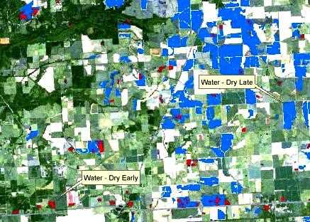
The Gulf Coast Joint Venture (GCJV) was established in 1988 as a conservation partnership in one of the priority habitat regions of the North American Waterfowl Management Plan. The GCJV region encompasses coastal marsh and associated habitats from Alabama to south Texas, and is geographically subdivided into 6 Initiative Areas - Mobile Bay, Coastal Mississippi Wetlands, Mississippi River Coastal Wetlands, Chenier Plain, Texas Mid-Coast, and Laguna Madre. Using remote sensing and Geographic Information Systems (GIS) technologies, the within-season and annual variation of surface water on seasonal or semi-permanent habitats within agricultural landscapes was quantified. Satellite imagery was acquired for wet, average, and dry years, based on NOAA precipitation data. Imagery was analyzed to determine the extent of surface water within various habitats including rice fields, fallow fields in rice rotations, range/pasture land, seasonal/moist soil wetlands, "hurricane ponds," and resacas in the Chenier Plain, Texas Mid-Coast and Laguna Madre Initiative Areas. Additional analyses evaluated the hydrological performance of private lands conservation programs and managed wetlands on public lands to better estimate the amount of foraging habitat available to waterfowl. Results from this project will provide baseline information to evaluate the effectiveness of conservation programs as they relate to habitat objectives specified in GCJV Initiative Area implementation plans.