Level II Ducks Unlimited conservation priority area, the primary migration corridor for several million ducks and geese in the Central Flyway
The Southern Great Plains contains wetlands of high value to waterfowl including playa lakes, shallow meandered rivers, large saline lakes, man-made ponds and reservoirs. Each provides unique and valuable wintering and migration habitat for several million waterfowl in the Central Flyway. An underlying conservation issue that affects wetlands in the SGP and may have potentially serious implications for waterfowl is allocation and use of water. Surface and ground water are used to flood restored wetlands and for irrigation to produce cereal grains, particularly corn which is an important source of energy for migrating and wintering waterfowl in the SGP.

Colorado | Kansas | Nebraska | New Mexico | Oklahoma
South Dakota | Texas | Wyoming
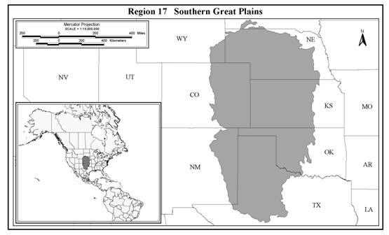
The Southern Great Plains conservation region (Region 17*) encompasses a large area extending from southeastern Wyoming and west-central Nebraska, south through eastern Colorado and west-central Kansas and Oklahoma, to eastern New Mexico and west-central Texas. Most of the region once consisted of semi-arid prairie interrupted by riparian corridors along major rivers (e.g., Platte River), with interspersed, continentally significant wetland complexes including the Rainwater Basin, Cheyenne Bottoms, McPherson Valley Wetlands, Hackberry Flat, isolated saline wetland complexes, and playa lakes. Collectively these wetlands are core of the Central Flyway migration corridor. The majority of wetlands in this conservation region are in private ownership, notable exceptions being Valentine NWR, NE (USFWS) Cheyenne Bottoms, KS (KDWP and USFWS) Hackberry Flat, OK (ODWC), and parts of the McPherson Valley Wetlands, KS (KDWP).
As with many other regions, wetland drainage and/or alteration of wetland hydrology have been substantial, with most drainage or alterations attributable to agricultural practices. For example, 91% of the original wetlands in the Rainwater Basin have been drained and converted to agricultural production (Tiner 1984). Approximately 70% of 589 playas >4 ha (or 33% of all playas) have been modified via construction of pits to concentrate runoff for use in irrigation of crops (Guthery and Bryant 1982). While these playas are not lost, their hydrology is altered in a manner that reduces their value to ducks via reducing the area available for growth of emergent vegetation and as foraging habitat (Gray 1986). This may be an important factor in that much of the food resource for migrating and wintering waterfowl is agricultural crop residue. Agricultural grains must be supplemented by natural foods so that birds are able to obtain the full range of nutrients for annual cycle events that occur in winter, particularly molt. Many remaining wetlands in this region have been altered, some positively and others negatively, by grazing and farming practices, siltation, and other factors (Guthery et al. 1982, Guthery and Stormer 1984).
An underlying conservation issue that affects wetlands and may have potentially serious implications for waterfowl in the SGP is allocation and use of water. Surface and ground water are used for irrigation to produce cereal grain, particularly corn (Bolen et al. 1989, Guthery et al. 1984). Waste grain provides an important source of energy for migrating and wintering waterfowl in the SGP, and probably has increased the carrying capacity (as determined by available food) of this conservation region (Baldassarre and Bolen 1984, Baldassarre et al. 1983).
Extensive use of water for irrigation has had contrasting effects on waterfowl populations. On one hand, much of the corn could not be grown in this region were it not for irrigation, and irrigation tail water can create favorable conditions for moist soil plant production in playa basins (Bolen and Guthery 1982, Guthery et al. 1982). Hence, irrigation can and probably has increased available food resources. Alternatively, many wetland basins have been drained or extensively altered by agricultural practices or to store irrigation water. The net effect likely has been an increase in agricultural foods (waste grain) and a decrease in available wetlands and associated moist soil habitat. Loss and degradation of natural wetlands may have reduced the amount of natural foods (moist soil plants, invertebrates) wherein birds cannot easily acquire essential nutrients that are not available in agricultural grains (Baldassarre and Bolen 1984).
Further, reduced number and area of wetlands may concentrate birds, making them susceptible to disease outbreaks, particularly avian cholera (Bolen et al. 1989, Friend 1987). In many years playas and wetlands in the Rainwater Basin are dry or greatly reduced in area and number by dry conditions. This further concentrates birds and increases the risk of mortality related to disease (Bolen et al. 1989, Friend 1987).
*Region 17 - NABCI Bird Conservation Regions 18 (Shortgrass Prairie) & 19 (Central Mixed Grass Prairie)
Another feature of this region that influences both the carrying capacity and distribution of migrating and wintering waterfowl is the presence of reservoirs (Ringelman et al. 1989). The semi-arid nature of this conservation region has stimulated construction of many reservoirs to hold water for irrigation and municipal water supply, with flood control, power generation, navigation, and recreation also driving construction. Ringelman et al. (1989) discussed the importance and relationship of reservoirs in this region to migrating and wintering waterfowl. They summarized information from the USFWS that indicate that there are 1,163 reservoirs encompassing 269,974 ha that are of high value to waterfowl, while another 571 encompassing 52,221 ha were available but considered of low value (Ringelman et al. 1989).
Overall, the wetlands of the SGP are of primary importance as migration habitat and they provide significant winter habitat for some species. Wetlands in this conservation region also serve as production habitat, though the number of birds produced is not well documented. The limiting factor in terms of waterfowl using the region is availability of flooded habitat.
Numbers of waterfowl wintering in the SGP region probably have increased with conversion of grassland to production of cereal crops, particularly with the advent of irrigation that permits corn production in the region, though no historical estimates are available (Bolen et al. 1989). The SGP conservation region is the primary migration corridor for several million ducks and geese in the Central Flyway. Additionally, depending on winter weather severity and wetland conditions, 500,000 to 4 million ducks and 250,000-1 million geese over-winter in this region (Bolen et al. 1989, Ringelman et al. 1989). The playa lakes alone are second in importance only to the Gulf Coast as winter habitat for waterfowl in the Central Flyway (Curtis and Beierman 1980), with estimates of waterfowl ranging from 500,000 to 2.8 million ducks and as many as 750,000 geese (Bolen et al. 1989). Mallards, pintails, green-winged teal and Canada geese are the most common winter residents.
While spring migrants make use of nearly all available habitats in this semi-arid region, the Rainwater Basin wetlands stand out in terms of concentrations of waterfowl. The wetlands in the Rainwater are particularly important spring staging habitat for pintails, mallards, white-fronted geese, Canada geese and snow geese. For many species of ducks, this is the final staging area prior to arrival on prairie nesting areas.
Some waterfowl production occurs on wetlands in the SGP conservation region. Mallards, redheads, blue-winged teal and cinnamon teal are known to successfully nest in playa wetlands, with as many as 25,000 ducks (mostly blue-winged teal and mallards) fledged in some years (Rhodes and Garcia 1981, Simpson et al. 1981). Total waterfowl production in the SGP conservation region has not been well studied.
Non-hunting mortality is the major factor affecting migratory birds in the SGP. Avian diseases, primarily avian cholera and botulism, are the primary source of mortality. Disease outbreaks are related to over-crowding on the limited wetland base in the SGP. Severe disease outbreaks occur in winter and spring when conditions are dry and severe winter weather persists for several days, concentrating birds on smaller areas of open water. However, it also has been suggested that there is a chronic low to moderate rate of disease-related mortality each year in this conservation region. Other factors, including contaminated water, uncovered waste oil pits, and pesticide pollution also contribute to total non-hunting mortality. Wetlands in the region are threatened by sedimentation, pit excavation, overgrazing, land leveling, and other factors. Water availability is a limiting factor in many years. Bolen et al. (1989) summarized disease and other mortality factors that affect birds in this region.
Within the SGP, the playa lakes winter over 90% of the mid-continent population of lesser sandhill cranes (Iverson et al. 1985, Tacha et al. 1994). Endangered whooping cranes migrate directly through the SGP region and occasionally stop to rest and forage, while wetlands throughout the SGP are heavily used by spring and fall migrant shorebirds (Bolen et al. 1989, Fischer et al. 1982). Playas, Hackberry Flat, and Cheyenne Bottoms are important stopover sites for and undetermined but large number of American avocets, Wilson's phalaropes, Baird's, buff-breasted, and semipalmated sandpipers and other species. Avocets, Wilson's phalaropes, snowy plovers, long-billed curlews and mountain plovers breed in this region. Grasslands in this region offer some of the better remaining habitat for greater prairie chickens and Henslow's sparrows. This region provides breeding habitat for most of the endangered interior least tern population in North America.
The SGPs conservation region takes in two NAWMP Joint Ventures - the Playa Lakes (PLJV) and the Rainwater Basin (RBJV). The PLJV has an objective to protect 20,639 ha, restore 4,047 ha and enhance an additional 10,117 ha. To date, the PLJVhas accomplished about 20% of their protection objective, 80% of their restoration objective and 38% of their enhancement objective. The RBJV has objectives to protect, restore, or create an additional 10,125 ha of wetlands, provide reliable water sources for a minimum of 33% of protected wetlands, and development and implementation of strategies that maximize wetland values to wildlife.
The causes of habitat loss and the biological consequences in both joint ventures are similar. Over-crowding of birds leads to disease outbreaks. Consequently, conservation programs of DU and its partners are similar throughout the SGP. Essentially, the over-riding needs are to protect existing wetlands, restore and/or enhance wetlands, and where feasible, provide a reliable source of water to assure availability of wetland habitat.
DU's participation in this region presently is focused on cooperating with state, federal and private partners to provide technical assistance related to wetland engineering, design and development and financial assistance with wetland development (Hackberry Flat, McPherson Valley Wetlands). DU does not currently have the financial or human resources to become extensively involved in delivery of a private lands program in the SGP conservation region. The Continental Conservation Plan identifies DU's future role in this region as cost-sharing habitat protection and enhancement activities and support of research on disease etiology, moist soil management of playas and winter mortality; and supporting resource policy issues that protect and enhance wetlands and associated uplands.
Share this photo