Level I Ducks Unlimited conservation priority area, the most important and threatened waterfowl habitat in North America
The Prairie Pothole Region is the core of what was once the largest expanse of grassland in the world, the Great Plains of North America. Its name comes from a geological phenomenon that left its mark beginning 10,000 years ago. When the glaciers from the last ice age receded, they left behind millions of shallow depressions that are now wetlands, known as prairie potholes. The potholes are rich in plant and aquatic life, and support globally significant populations of breeding waterfowl. Agricultural development caused considerable wetland drainage in the area. The Great Plains and Prairie Pothole Region are No. 1 on the 25 most important and threatened waterfowl habitats on the continent.

North Dakota | South Dakota | Iowa | Minnesota | Montana
Alberta | British Columbia | Manitoba | Saskatchewan
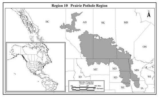
The Prairie Pothole Region (Region 10*) forms the core of what was formerly the largest expanse of grassland in the world – the Great Plains of North America. It encompasses some 700,000 km2, stretching from the Peace Lowlands of northwestern Alberta and northeastern BC, southeast to the Tall Grass Prairie of Iowa. When the glaciers from the last ice age receded across this landscape about 10,000 years ago, they left behind millions of shallow depressions that are now wetlands known as prairie potholes. Since that time, these pothole complexes, rich in plant and aquatic invertebrate life, have supported populations of breeding waterfowl unmatched anywhere in the world. In some portions of the region, potholes occur in densities exceeding 70 ponds/km2, creating a wetland community that supports up to 50 breeding duck pairs/km2. Despite wetland drainage and conversion of grasslands, the PPR remains the most important habitat for breeding waterfowl in the world.
The last 125 years have seen a dramatic change in this landscape's ability to support breeding waterfowl. Settlement by Europeans has brought with it significant impacts on the ecological function of the PPR. The nutrient-rich soils have proven to be highly productive for growing annual crops, and the vast grasslands supported the introduction of millions of grazing livestock. To facilitate agricultural development, pothole wetlands have been subjected to considerable drainage and consolidation. Though variable across the PPR, estimates suggest that on a localized basis anywhere from 50-90% of these potholes have been lost or severely degraded, and this trend continues today. But drainage has not been the only impact on PPR wetlands. Years of cultivation and soil erosion have also resulted in many more potholes being filled, and the cumulative effect of agricultural chemicals have impacted the survival and composition of aquatic plant and invertebrate communities.
In many areas across the PPR, upland habitats have been under even greater siege than the wetlands. Native prairie has been cultivated, and today annual crops dominate much of the region. Recent analysis has revealed that some parts of the PPR have suffered losses of native habitat in excess of 70%. In the PPR of Canada, the cropland base has increased by 30% in the last 25 years alone. This alarming rate of native habitat loss shows no signs of abating. Up to 3% of the remaining native uplands continue to be converted to cultivated lands on an annual basis in some areas of the PPR. Conversion of these upland habitats is not the only threat to the integrity of the habitat for breeding waterfowl. Poor range use and management practices, and increased stocking rates of grazing livestock, have resulted in much of the remaining native grasslands being severely degraded. In addition, fragmentation of critical upland habitats has been shown to have negative impacts on waterfowl production. These changes in the landscape have also had an impact on the predator community to the detriment of breeding waterfowl. In some areas of the PPR, recruitment of waterfowl on an annual basis is unable to keep pace with the mortality caused by predation.
*Region 10 – NABCI Bird Conservation Region 11 with Peace River Parkslands added.
With only remnant patches of grassland remaining in many areas, ducks are forced to lay their eggs in fragments of prairie that have escaped cultivation. Predators, in particular red foxes, skunks, raccoons, badgers, and coyotes, can more easily encounter nests in these small patches. Moreover, changes in the landscape that accompanied European settlement -- extirpation of wolves and other large carnivores, farmsteads and culverts that provide den sites, and agricultural foods that better enable mammals to survive through the winter -- have also transformed the predator community in the PPR. Without wolves and coyotes to suppress their numbers, foxes are much more abundant than they were before settlement, as are skunks and raccoons. The dual effects of grassland fragmentation and alteration of the predator community have resulted in very low duck nest success rates and high mortality of nesting hens. Of all the demographic parameters that are responsible for change in mid-continent mallard populations, nest success and hen mortality during breeding are clearly of greatest importance (Steve Hockman et al. IWWR, unpubl. manuscript). There is strong evidence that these same parameters are driving other mid-continent dabbling duck populations as well as many other grassland bird species.
Although wetlands occur throughout most of the region, their density varies according to surface form patterns, relief, composition of glacial materials and human activities. About 40% of the PPR consists of ground or hummocky moraines, which produce landscapes pitted with numerous depressions of varying size. Wetland densities can vary from 0 to 74 ponds/km2. The flatter landscapes (60% of the region) are comprised of mainly lacustrine and fluvial material and wetland density averages <5/km2. In total, the U.S. portion of the PPR is estimated to contain 1,688,000 ha of wetlands (Prairie Pothole Joint Venture Concept Plan). In Canada there are estimated to be between 2 - 7 million wetlands, depending on weather conditions, and in wet years the area occupied by these basins can exceed 30 million ha (DUC wetland inventory).
The PPR has a continental climate, with extremes in both temperature and annual precipitation. Because prairie potholes are dependent on snowmelt, surface runoff, and direct precipitation as sources of water, the abundance of wetlands varies both seasonally and annually. Some larger PPR wetlands may be hydrologically connected to groundwater, but smaller wetlands are often perched above the water table. These small potholes are often linked hydrologically and thereby supply, obtain, or pass water to other, adjacent potholes. During springtime, ephemeral, temporary, and seasonal wetlands typically contain water for only days, weeks, or 1-2 months, respectively. Wetlands with longer hydroperiods, classified as semi-permanent or permanent wetlands, usually retain water throughout the growing season, although their water levels also decline due to evaporation, transpiration, and seepage. Under extreme drought conditions, entire wetland communities may dry up. More commonly, however, wetland densities vary from 0.8 potholes/km2 during a severe drought to 4.4 potholes/km2 during near average water conditions (Cowardin et al. 1995). This wet-dry cycle rejuvenates prairie potholes by exposing organic matter to aerobic decay, thereby making nutrients more available when the next wet period returns. Dry periods also allow the germination of aquatic plant seeds and set back wetland succession. The dynamic nature of wetlands in the PPR, combined with the high density of diverse wetland types, makes wetland communities of the PPR among the most productive systems on earth and ideal waterfowl breeding habitats. Wetlands are the magnets that attract waterfowl to the PPR.
The PPR is a large landscape, and in any given year weather conditions are not uniform across the region. Waterfowl respond to habitat conditions within the region, settling in areas with the best wetland and upland conditions. Although DU can not control annual precipitation, we can work towards conservation of wetland and uplands so that in wet years habitat in the PPR is in the best condition for maximum waterfowl response.
Despite the habitat degradation that has occurred across the PPR in the last century, this region continues to be the most important to breeding waterfowl in North America. In wet years, 70% or more of the continent's duck production originates in the PPR (Fig. 1). It is especially important on a continental basis to breeding northern pintails, mallards, canvasbacks, redheads, gadwall, blue-winged teal and northern shovelers. Although populations across the Canadian prairie and parkland have not responded to the levels expected, the relatively wet years experienced during the 1990s have resulted in most of these species reaching and surpassing the regional population goals as established by the NAWMP. One exception has been the northern pintail. This grassland-dependant duck has struggled despite the generally favorable water conditions in the last decade. Studies show that breeding pintail populations have decreased in excess of 50% in the last 20 years, with no significant improvement to the trend. The shallow, nutrient-rich wetlands and fragile grasslands on which these birds rely have been impacted particularly hard despite recent improved moisture conditions.
Lesser scaup are another species that has historically relied on the PPR for breeding habitat, particularly in the northern portion of the region where the prairie/parkland transitions to the mixed-wood boreal forest. Again, despite the favorable moisture conditions experienced in the last decade, scaup have not responded with improved breeding success. As a result, scaup are hovering at population levels below those established under the NAWMP as plan goals.
Several million ducks and geese pass through the region each spring. Even in regions that have experienced substantial wetland losses, such as Iowa, valuable migration habitat is often available in early spring when the ground is still frozen and drainage ditches are not yet flowing. In autumn, an estimated 8 - 10 million ducks and 0.5 - 1 million geese migrate south through Iowa, en route to warmer climates. A few, including an average 106,000 ducks and 138,000 geese, remain during winter in the PPR or adjacent areas. However, the PPR is most critical for breeding waterfowl.

Fig 1. Total ducks observed in the May survey in the Prairie Pothole Region.
Recruitment rates, defined as the number of young female ducks that enter the fall population per the number of adult females in the spring population, are highly variable within the PPR. However, there is a strong relationship between recruitment and the quality and amount of upland cover. In recent years recruitment rates and brood production in the U.S. portion of the PPR have exceeded those in Canada (Fig. 2). This change from historic patterns is thought to be a result of exceptional precipitation and excellent upland conditions in the U.S., primarily due to an initiative called the Conservation Reserve Program (CRP). In the U.S. PPR, recruitment rates have been estimated for each of the USFWSs Wetland Management Districts. Those simulations, made as part of the Multi-Agency Approach to Planning and Evaluation, revealed that 9 of the 14 Districts had recruitment rates above the maintenance level of 0.5 needed to sustain or increase duck populations. These simulations were made assuming the current distribution of CRP land.
As the percentage of grassland in a landscape increases, so does the success of duck nests (Reynolds et al. 2000). This relationship, while accounting for a relatively small percentage of the total variation in nest success, is nonetheless statistically significant for five duck species in the PPR. However, as with wetlands, the distribution of grassland is not uniform within the PPR. Because most soils in the Missouri and Prairie Coteau are rocky and the topography is rolling, much of this physiographic region is devoted to livestock production (pasture and hayland), and significant areas of native grassland remain. Consistent with the relationship between grassland area and nest success, duck nest success in the Coteau appears to be relatively high. In contrast, prior to 1985 the Drift Plain of the Dakotas, like most of Minnesota and Iowa, was dominated by cropland and contained very little grassland. Duck nest success in many places was distressingly low -- below the threshold necessary to sustain duck populations. That changed with the 1985 Farm Bill and the CRP.
CRP was authorized as a program to reduce soil loss on highly erodible land, reduce crop surpluses, and improve wildlife habitat. Under the program, farmers could apply for enrollment in CRP and, if accepted, were obligated to plant perennial cover in exchange for an annual payment. Most contracts were for 10 years. By 1985, it was widely recognized that inadequate grassland habitat was responsible for low duck nest success. Because of the potential for CRP to restore grasslands in the PPR, conservationists worked to persuade the U.S. Department of Agriculture to designate the entire PPR as a Conservation Priority Area due to its wildlife, and particularly, waterfowl values. This designation made nearly all previously cropped land in the PPR eligible for CRP, regardless of soil erodibility. Subsequent modifications to the implementation rules and scoring of CRP afforded advantages to farmers who were willing to restore wetlands and plant cover that was beneficial to wildlife.

Fig. 2. Duck productivity, expressed as July broods/100 ducks observed in the May survey.
By any measure, CRP was a huge success for waterfowl conservation. About 1.9 million ha of former cropland, 7% of the land base in the U.S. PPR, was enrolled in CRP. When water returned to the region in 1993, ducks responded. Duck nest success in CRP exceeded rates reported in earlier studies, and CRP had the added benefit of increasing the nest success in nearby Waterfowl Production Areas (Reynolds et al. 2000). Research on the effects of CRP concluded that duck nest success increased 46% as a result of CRP, and that CRP resulted in an additional 10.5 million ducks recruited into the fall population during 1992-97 (Reynolds et al. 2000). The weight of the evidence indicates that ducks will readily accept planted cover in which to nest and, given an adequate amount of cover in the landscape, can achieve nest success rates adequate to increase duck populations.
Clearly a focus of our conservation efforts must be the maintenance and expansion of cover programs such as CRP in the U.S. Unfortunately Canada does not have a similar program and much of the Canadian PPR, particularly in Saskatchewan, remains intensively cropped. Therefore the implementation of a similar, aggressive, extensive cover program in Canada is needed.
The NAWMP uses the period 1970-'79 as a benchmark against which to measure current waterfowl populations. Most Joint Ventures (JV's) under the NAWMP have adopted species population goals equal to the average of the 1970s. In recent years most species have reached or exceeded the numeric NAWMP goals in the PPR, with the notable exceptions of pintails and scaup (Table 4). However even for the species that have apparently achieved target goals, the population response has not been as great as expected based on historical patterns between ducks and precipitation. There is clearly a need for enhanced habitat conservation efforts if target populations are to be sustained.
Table 4. Breeding duck population status and goals for the 10 most common species in the PPR (as stated in the 1998 plan update).
| Species | 1999 Population x 1000 |
NAWMP goal x 1000 |
| Mallard | 10,806 | 8,200 |
| Northern Pintail | 3,058 | 5,600 |
| Gadwall | 3,236 | 1,500 |
| American wigeon | 2,920 | 3,000 |
| Green-winged teal | 2,631 | 1,900 |
| Blue-winged teal | 7,950 | 4,700 |
| Northern shoveler | 3,890 | 2,000 |
| Redhead | 973 | 640 |
| Canvasback | 716 | 376 |
| Scaup | 5,384 | 6,300 |
The same complexes of wetlands and grasslands that make the PPR the core breeding area for North America's waterfowl also make the region extremely attractive to other migratory species. Besides ducks, geese, and swans, 225 other migratory bird species can be found in the PPR. Recent studies have shown that populations of many of these birds are diminishing at an alarming rate. These include numerous species of shorebirds, wading birds, and grassland songbirds. Included among these are priority species such as whooping cranes, Franklin's gulls, yellow rails, burrowing owls and piping plovers. During spring migration, wetlands are used by Hudsonian godwits, American golden plovers, white-rumped sandpipers, and buff-breasted sandpipers. Shorebirds such as Wilson's phalaropes, marbled godwits, and American avocets are common breeders in prairie pothole wetlands. In areas where large tracts of grassland still exist, priority species such as Baird's sparrows and Sprague's pipits are common.
The habitat programs within the PPR which are being delivered by DU, other NAWMP partners and a variety of other government and non-government wildlife agencies, are among the most aggressive on the continent. In excess of 1.6 million ha of critical wildlife habitat have been influenced through our conservation programs in Canada. These programs vary widely in terms of both security and impact, ranging from perpetual protection of critical native habitats through legislation or ownership, to conversion of land use to functions more favorable to wildlife, to stewardship programs that are little more than recognition of landowners who have decided not to alter key wildlife habitat components within their land holdings. In the U.S. PPR, 140,000 ha have been protected or restored by DU. Although wetland restorations, upland management, and intensive techniques like nesting islands and predator exclosures form the majority of U.S. projects, increasing attention is being devoted to protecting intact habitats through conservation easements. Unfortunately, despite the magnitude of these efforts, critical habitats continue to be lost and degraded at a level that surpasses the restoration and protection capacity of our current conservation programs.
A wide array of partners and programs are at work in the PPR. In the U.S., the backbone of habitat secured for waterfowl is provided by the USFWS, which owns about 366,000 ha of land in NWRs and Waterfowl Production Areas. State agencies own another 192,000 ha of public Wildlife Areas. A growing component of land protection is wetland and grassland easements, obtained and held mostly by the USFWS. Through 1999, nearly 140,000 ha were protected under grassland easements in North and South Dakota. Quasi-governmental organizations such as the North Dakota Wetlands Trust are actively cost-sharing habitat restoration projects. National and local non-profit conservation organizations are securing important parcels of habitat, although at nowhere near the scale of the agencies. DU works in collaboration with these agencies and organizations under the umbrella of the NAWMP joint ventures, in this case the Prairie Pothole Joint Venture (PPJV). As of 1999, the PPJV has protected 226,081 ha, restored 90,327 ha, and enhanced 230,104 ha in the U.S. PPR.
Agricultural programs continue to shape the landscape of the PPR. In addition to CRP, the Wetlands Reserve Program (WRP) has facilitated the protection and restoration of many wetland habitats in Minnesota and Iowa. The opportunity exists to expand WRP in these states. After leveraging with other state funding sources like Re-invest In Minnesota, the state was able to convert short-term WRP easements to perpetual easements, allowing the permanent protection of wetlands. There is a need to develop similar programs in the Canadian prairie.
In Canada, conservation partnerships are equally important. Through partnerships such as NAWMP, DU has secured over 490,000 ha of wetland and uplands. Provincial wildlife agencies and other non-governmental organizations (NGO's) currently control an additional 830,000 ha.
The Prairie Pothole Region has been the focus of more waterfowl conservation work by DU, and others, than any other region of the world. It is also one of the most important agricultural regions in North America and has therefore been the target of many land use, agricultural and wildlife conservation regulations and public policies in Canada and the U.S. These have been directed under different social, climactic, political and economic realities and now have an overwhelming influence on how waterfowl conservation can be accomplished in each country. Thus, DU's conservation plan, while understanding that the waterfowl don't recognize political boundaries, must address the realities in each country if realistic waterfowl conservation programs are to be developed.
In 1999, the staff from DU in both the U.S. and Canada joined forces to develop a Conservation Vision for the PPR. The document sets forth a vision and underlying principles for DU's conservation programs in the entire PPR, quantifies population objectives, and sets forth wetland and upland habitat goals.
Our vision: "A mosaic of natural, restored and managed landscapes capable of perpetually sustaining populations of waterfowl and other wildlife."
Share this photo