Level III Ducks Unlimited conservation priority area, containing some of the most productive waterfowl breeding habitat in North America
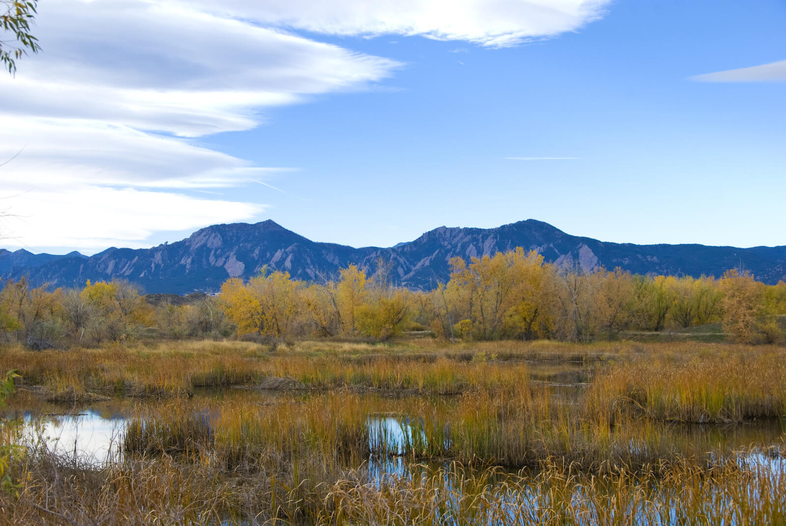
For thousands of years, waterfowl have found desirable habitat in the Rocky Mountains for migration and for breeding. Melting snow and early spring rains flood mountain streams; these waters spread out to form floodplain wetlands along river corridors. The spring that also fed marshes in the mountain valleys; these basins received their water either directly from mountain streams or from groundwater seeping to the surface. These shallow wetlands beckon to breeding waterfowl as well as birds needing rest spots during their travels north. The Rocky Mountain range of Montana, Wyoming and Colorado continues to offer wetland habitat for those birds drawn to higher elevations. Although small in size, the intermountain valleys of the Rockies contain some of the most productive waterfowl breeding habitat on the continent with nesting densities reaching 1,000 per square mile in some areas and nesting success averaging 26%. Unfortunately, the wetland habitats of the Rockies are increasingly threatened by competition over limited water supplies and increasing demands on space from a growing human population.

Arizona | Colorado | Idaho | Montana | Nevada | New Mexico | Oregon
Utah | Washington | Wyoming
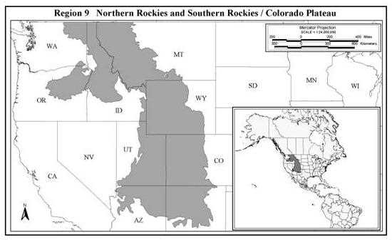
The Northern Rockies and Southern Rockies / Colorado Plateau Regions (Region 9*) include several ecosystems ranging from alpine tundra to sagebrush flats. Much of the diversity of the RCP is attributable to its topographic relief, which ranges from 1,000 to 4,300 m. Elevation changes result in ecosystem regions or "life zones" characterized by differences in precipitation, humidity, temperature, growing season, wind, exposure, and soil conditions. The four life zones recognized in the Rocky Mountains—Lower Montane, Upper Montane, Subalpine and Alpine—possess unique flora and fauna. The Alpine has few woody species (mostly willows), but contains abundant grasses and forbs characteristic of vegetation at much higher latitudes. Subalpine areas contain Englemann spruce and subalpine fir. Upper Montane habitats are somewhat drier, and are dominated by blue spruce, Douglas fir and several other coniferous species. Lodgepole pine and aspen are the most common species in Lower Montane areas. Depending on the latitude, sagebrush, rabbitbrush and black greasewood are the dominant species in the intermountain basins.
Waterfowl habitats in the RCP have several attributes that set them apart from their prairie counterparts. First, montane wetland communities are relatively intact compared with the widespread wetland degradation typical of the northern Great Plains. This more nearly pristine condition reflects the rugged topography and generally poor soils of the region, which favors ranching, timber harvest, and mining over farming. Additionally, many areas are afforded some degree of natural resource protection by virtue of their inclusion in the National Forest System or as BLM holdings. The most secure areas are lands set aside as wilderness areas or research natural areas. Second, except where locally affected by mining operations and ski areas, for example, upland plant communities are still dominated by native plant species. Third, although the magnitude of the snowpack and rainfall varies annually, precipitation is almost always sufficient to provide adequate water for ducks and geese. Thus, waterfowl habitats in the RCP is relatively stable compared with those in the prairies.
The geology and topography of the RCP create a greater diversity of wetland types than are found in the prairies. Annual primary production decreases with elevation, so wetland succession proceeds much more slowly in montane wetlands than in low elevation ponds. Most high elevation wetlands are slightly acidic to circumneutral and contain relatively small amounts of dissolved nutrients compared to a typical prairie wetland. Accordingly, only some wetland communities—intermountain basin wetlands, beaver ponds, glacial ponds, and riparian corridors—are heavily used by waterfowl. Understanding the nature of these wetland communities is important to the success of any waterfowl management initiative in the RCP.
The intermountain basins or "parks" of the RCP contain the most important waterfowl habitats in the region. The flat or rolling topography typical of mountain parks, which originated from tectonic and volcanic events during the formation of mountain ranges, is underlain by deep layers of alluvial material eroded from the surrounding mountains. Although relatively few in number—33 parks have been identified in the RCP—intermountain basins are often several hundred square kilometers in size. Many parks are considered cool deserts because of the low precipitation created by the rain shadow of surrounding mountains. The average frost-free period may be <2 months. Despite low seasonal temperatures, ratios of precipitation to evaporation are usually <1, causing the development of pedocal soils. Where alkali deposits occur in poorly drained areas, salt-tolerant plants such as black greasewood and saltgrasses are common. Less saline areas typically contain wheatgrasses, bluegrasses, sedges and rushes, or shrubs such as sagebrush and rabbitbrush. Ranching and haying are the most common land use, but some grain crops and cold-weather vegetables are grown in more temperate parks. Many intermountain basins contain relatively few wet areas, but some—such as the 13,000 km2 San Luis Valley in south-central Colorado—possess abundant wetlands. Wetlands are formed by spring runoff, which creates shallow water areas and recharges the persistently high water tables, and by artesian flows and impoundments. Lakes and reservoirs provide important migratory staging and molting habitats, and lake margins attract breeding waterfowl. High densities of aquatic invertebrates such as freshwater shrimp and the larvae of dragonflies, midges, flies, and mosquitoes abound in these wetlands, providing abundant food for waterfowl.
*Region 9 - NABCI Bird Conservation Regions 10 & 16. Region 10 in Canada is covered in above section.
Beaver ponds most commonly occur in mid-elevation, montane valleys where the slope is <15%. Because beaver ponds are often clustered in "flowages" along suitable lengths of streams and rivers, they provide a valuable wetland community well suited to the needs of breeding waterfowl. Densities of 5 to 10 ponds/km of stream are common, increasing to as many as 42 ponds/km in excellent habitat with high beaver populations. Wetlands created by beaver possess relatively stable water levels maintained by precipitation and runoff. However, beaver flowages themselves may be somewhat ephemeral in nature, and usually are abandoned within 10-30 years, after beaver deplete their food resources. Beaver ponds act as nutrient sinks by trapping sediments and organic matter that otherwise would be carried downstream. This function enhances wetland fertility and the plant and aquatic invertebrate communities exploited by waterfowl. Invertebrates typical of running water systems are replaced by pond organisms such as snails, freshwater shrimp, and the larvae and immature stages of caddisflies, dragonflies, flies, and mosquitoes. Structural cover provided by flooded willows, alders, sedges, burreeds, and other emergents affords ideal habitat for waterfowl breeding pairs and broods.
Glacial ponds include both small wetlands formed behind lateral and terminal moraines of glaciers, and "kettle ponds" created by the same glacial process that formed the prairie "potholes"—ice embedded in glacial till melted after glaciers retreated, forming depressions that later filled with water. Glacial wetlands most commonly occur in mountainous terrain. Often, these ponds are dependent solely on spring runoff and summer precipitation for water. Therefore, water levels recede during summer, while density and abundance of herbaceous, emergent vegetation increases. Despite dynamic water levels, natural succession is slow. Peat accumulations indicate that some glacial ponds have persisted as wetlands for >7,000 years. Northern mannagrass, sedges, and reedgrasses are common emergent plants in these wetlands, as are submerged species such as pondweeds, watermilfoils, and cowlilies. Often, the size and physical setting of glacial ponds restrict waterfowl use to dabbling ducks, which can land and takeoff in confined areas. The shallow water of these ponds is unsuitable for sustaining fish populations, which might otherwise compete with waterfowl for aquatic invertebrate foods. The abundant plant and animal foods in glacial ponds make these wetlands very attractive to waterfowl.
The headwaters of many major river systems begin in the RCP. At high and mid-elevations, these streams and rivers often flow unrestricted by major dams and diversions. Accordingly, overbank-flooding wetlands develop along riparian corridors during spring runoff, creating potential habitat for waterfowl. Unfortunately, the timing of runoff, from late April and May in Lower and Upper Montane Zones to June and early July in Subalpine areas, may actually be detrimental to waterfowl nesting along river margins or on islands in the main channel. It is not unusual for nests of ducks and geese to be flooded by runoff. Nonetheless, the backwaters, sloughs, and old oxbows associated with western riparian areas provide important benefits to waterfowl during spring and fall migration, and for waterfowl that select nesting sites on higher ground away from flood-prone areas.
Other riverine systems in this region have been negatively impacted by significant man-made alterations, including dams and flood control levees. Most of this alteration was implemented to improve agricultural viability within the region by storing water for irrigation and preventing flooding of croplands and haylands. While these alterations to natural hydrology have negatively impacted waterfowl habitat, many of these systems continue to provide important resources to waterfowl and offer ideal locations to focus habitat conservation activities. The Baker Valley and Lower Powder River Valley in Baker County, Oregon provide significant resources to spring migrating waterfowl and have been the focus of several conservation projects. The Grande Ronde Valley in northeast Oregon is the home of the Ladd Marsh Wildlife Area. Several projects have been completed, or are underway, in this area. Combined, these projects will restore approximately 506 ha of wetland habitat, providing significant benefits to both migrating and locally breeding waterfowl. The Kootenai River valley in the Idaho panhandle is another floodplain system that has been extensively altered by levee construction. Several projects have been completed to restore over 405 ha of wetland habitat in this area.
Waterfowl populations in the RCP have not been well studied. Most research has been conducted in mid-latitude habitats between 2,100-3,000 m elevation. Surprisingly, waterfowl are common in these areas. Generally, peak waterfowl populations occur during spring and fall migration periods, particularly in the intermountain basins and riparian corridors. In beaver ponds and glacial wetland habitats, numbers of waterfowl decline as females proceed with incubation and males seek larger wetlands for the molt. Often, a molt migration occurs from higher elevation forested habitats to large lakes and reservoirs in intermountain basins. During fall, post-fledging young birds also move toward lower-elevation staging areas in mountain parks. Most mid-latitude montane wetlands freeze during October, greatly reducing the amount of available wetland habitat. Some wetland areas, however, such as the San Luis Valley in Colorado, retain open water areas as a result of warm water flowing from springs and artesian wells. Major river systems also afford winter habitat, particularly if cereal grain crops or other foods are located nearby.
Species composition of the waterfowl in the RCP varies seasonally and in relation to the wetland community (Table 2). Mallards and green-winged teal are usually the most common species in both intermountain parks and high elevation Montane and Subalpine zones. Gadwalls, northern pintails, American wigeon, cinnamon teal, northern shoveler, redheads, lesser scaup, and Canada geese are other common breeders in the intermountain basins. Trumpeter swans are important year-round residents in the northern RCP in and around Yellowstone NP. In beaver and glacial ponds of the Upper Montane and Subalpine zones, ring-necked ducks, Barrow's goldeneyes, buffleheads, and gadwalls are common. The peak of nest initiation for early-nesting ducks (mallards and green-winged teal) varies from early May to early June, depending on snow conditions and wetland availability. Late-nesting species such as ring-necked ducks begin nesting nearly a month later than early-nesting species.
The waterfowl population in the RCP is not known, although it is recognized that breeding densities of waterfowl vary greatly within the region (Table 3). This variation is largely attributed to wetland density and the availability of open water to attract and hold spring migrants. Wetlands larger than 0.4 ha receive most of the use by breeding ducks, although much smaller wetlands are also frequented. Considerably larger wetlands are needed to attract molting birds and fall migrants. Some intensively managed habitats achieve remarkable high breeding densities. For example, the 57 km2 Monte Vista National Wildlife Refuge (MVNWR) in Colorado's San Luis Valley averaged 107 duck nests/km2 over a 27-year period, and some individual wetland units exceeded 1,158 nests/km2 in some years (Gilbert et al. 1996). This compares favorably to nesting densities in the best prairie habitat. Moreover, at MVNWR the Mayfield duck nest success is estimated at 26-29%. The relatively unfragmented habitat and indigenous predator community typical of many areas of the RCP undoubtedly contributes to this high nest success. The combination of high nest success and potentially high breeding densities underscores the management potential of some portions of the RCP.
A few waterfowl populations depend heavily on the resources provided in the RCP. The mid-continent trumpeter swan population is centered in the region, and is heavily dependent on the submergent vegetation that develops in the wetlands and river systems of northwestern Wyoming and northeastern Idaho. Despite the many problems these birds encounter when trying to over-winter in this area, many individuals persist in being non-migratory. This poses special management problems. In addition to swans, the entire Rocky Mountain population of greater sandhill cranes is largely confined to the RCP, from their primary wintering grounds in New Mexico to their breeding habitats in Idaho and Montana. During both spring and fall migration, the entire population migrates through the San Luis Valley, Colorado. Cranes feed heavily on waste barley and other agricultural and natural foods during their stay in the Valley, during which they acquire important nutrient reserves. Wetlands of the San Luis Valley are vital as loafing and roosting sites for these cranes.
Elevational guilds of other birds species have been noted for the RCP. In the Alpine Zone, the brown-capped rosy finch and white-tailed ptarmigan are important species. The Williamson's sapsucker, Virginia's warbler, and Lewis' woodpecker are found in mid-elevation sites, along with blue grouse and the black swift. Most of the world's breeding gray vireos occur in the pinion pine-juniper ecosystem. Lowlands support sage grouse and provide critical breeding areas for mountain plovers.
It is difficult to generalize about the human impacts on wetlands and upland habitat in the RCP because the region is so vast and diverse. Habitat degradation tends to decrease with increasing elevation, partially because high elevation habitats tend to be remote, in public stewardship, and have topography and soils that are not conductive to landscape-level impacts. Nevertheless, localized effects are apparent even in these high elevation ecosystems. In some areas, logging activities on both public and private land have degraded wetland basins through sedimentation and physical disturbance. Some diversion ditches reach even the highest headwater streams, altering the hydrology of downstream wetlands during times of irrigation demand. Livestock often concentrate around wetlands, particularly during dry summer periods, with localized effects on wetland aquatic vegetation and substrate.
Before the arrival of Europeans, 60-400 million beaver occupied North America. The RCP region was particularly rich in beaver. However, by 1900 beaver populations had been so heavily exploited that some state wildlife agencies considered them on the brink of extinction. In most portions of the RCP beaver did not regain significant populations until the 1950s, and some areas have still not recolonized. Although the number of ponds created and maintained by beaver during pre-settlement times will never be known, it is certain that these wetlands provided extensive waterfowl habitat that no longer exists in the region (Ringelman 1991).
In lower elevation systems, extensive alteration to natural hydrology has been implemented, most often associated with development of agricultural activities. Dam construction and flood control levees have effectively drained many floodplain marshes, reducing waterfowl habitat. Farming activities in these floodplains often provides suitable foraging habitat for many waterfowl species, primarily during migration periods. However, the loss of wetland habitat has significantly reduced the value of these areas for locally breeding waterfowl. Examples of this type of loss can be seen in the Baker Valley, Powder River Valley and Grande Ronde Valleys of Oregon and the Kootenai River Valley in the Idaho panhandle.
The newest threats to wetlands stem from the pressures imposed by human population growth and affluence. Condominiums and retirement homes are sprouting in mountain valleys, directly and indirectly impacting wet meadow habitats. Water to serve the domestic needs of the new residents and to make artificial snow on ski slopes has depleted streamflows. Farther downstream, water is diverted into reservoirs for storage and flood control, and groundwater is pumped to irrigate cropland. As surface and groundwater hydrology is altered, so too are the hydrologic regimes of shallow wetlands. However, not all water diversion has been detrimental to waterfowl. Irrigated hayland provides shallow, flooded habitat that is attractive to breeding pairs, and small to moderate-sized impoundments provide new wetland habitat along the margins and inlet. In places, small grains and legumes are cultivated, and waterfowl feed heavily on the waste that remains after harvest.
The eastern half of the Intermountain West Joint Venture (IWJV) of the NAWMP includes the RCP region. Because the area is so vast, the IWJV has identified focus areas in which program delivery will be concentrated. Within the RCP there are about 50 focus areas of the IWJV. This joint venture has an objective of protecting 607,300 ha, restoring 202,430 ha, and enhancing 202,430 ha of waterfowl habitat. Unlike other regions of the country, much of the land in the RCP is publicly owned. Many state and federal agencies have programs to manage and protect wetland and wildlife habitat in the region. In Colorado, the partnership to protect wetlands has been particularly strong, involving the Colorado Division of Wildlife, the USFWS, and the Great Outdoors Colorado Trust. In Oregon, two NAWCA grants have focused wetland conservation actions in the Blue Mountains Focus Area while another NAWCA grant was centered on the Kootenai River valley in the Idaho panhandle.
Ducks Unlimited's "High Country Wetlands" initiative prioritizes 18 focus areas within the RCP. In Montana, these focus areas are the Flathead Valley, Bitterroot Valley, Blackfoot Valley, Clark Fork Valley, Beaverhead Valley, and the Centennial Valley. Focus areas in Wyoming include the Bighorn Valley, Green River Valley, Upper North Platte Basin, Bear River Valley, Wind River Basin, and the Laramie Basin. Colorado focus areas are in the Yampa Valley, North Park, Middle Park, South Park, Colorado-Gunnison Valley, and the San Luis Valley. Principal complexes where work will occur based out of DU's Western Regional Office include Pend 'Oreille (ID), Kootenai (ID), Okanagon (WA), Scabland (WA), Blue Mountains (OR), Green River (UT), and the Middle Rio Grande (NM). These rich wetland communities, many of which lie along riparian areas or within intermountain basins, contain outstanding waterfowl habitat but face threats from human development and water depletions. Accordingly, DU will concentrate our conservation programs in these areas.
Share this photo